Category: Uncategorized

New moorings deployed to strengthen the South Atlantic observing system

An international effort enhances knowledge of currents and ecosystems in a data-sparse region of the global ocean.

To extend a network of observations in the South Atlantic Ocean, two new scientific, full-depth, instrumented moorings have been deployed off the eastern coast of South America. These tall moorings will measure variations in the Atlantic circulation – a system of ocean currents affecting life in the ocean as well as the weather and economy of coastal nations.

The Atlantic Meridional Overturning Circulation (AMOC), consisting of an upper-ocean northward flow compensated by a southward deep-ocean flow, is a main engine of the Earth’s climate system. This upper AMOC cell is connected to deep-water formation and sinking in the subpolar North Atlantic and upwelling in the Southern Ocean. Beneath the upper cell is a weaker abyssal cell, sourced by the sinking of dense water near Antarctica.

With global warming the system is thought to become weaker. As well as such long-term circulation changes, natural variations on shorter timescales occur. These may be due to reductions of sinking water in the north, but also to changes in the water mass exchange in the south.

SAMOC/SAMBA mooring deployment
Deployment of the moorings in the southwest South Atlantic from the ARA Austral research vessel in December 2022.
Image credit: Michele Baqués.

“The South Atlantic is particularly important,” says Peter Brandt, professor at the GEOMAR Helmholtz Centre for Ocean Research.

“Changes in the AMOC that result from water mass exchanges between the Atlantic and the Indian and Pacific oceans, can best be detected in the south, and then compared to changes originating in the well-observed North Atlantic,” he explains.

Peter Brandt
Peter Brandt from GEOMAR and TRIATLAS emphasizes the importance of contributing to international data collection. Image credit: Ellen Viste / TRIATLAS

“The South Atlantic is the only ocean basin with a net equatorward heat transport, and where freshwater transports may be key to AMOC stability. It is also the basin where the upper and abyssal overturning cells of the AMOC are both important,” adds María Paz Chidichimo, leader of the research involving the new tall moorings.

Chidichimo is a researcher at the Argentine Scientific Research Council (CONICET), the Hydrographic Service and the French-Argentine Institute for Climate Studies, CNRS/IRD/CONICET UBA UMI 3351 IFAECI, in Buenos Aires.

María Paz Chidichimo
María Paz Chidichimo from the EU Horizon 2020 project iAtlantic leads the scientific work related to the moorings. Credit: Private

The new moorings contribute to an existing measurement array along 34.5 degrees south on both sides of the Atlantic Ocean, termed South Atlantic MOC Basin-wide array (SAMBA). The SAMBA array is a component of the multi-national South Atlantic Meridional Overturning Circulation (SAMOC) Initiative, established in 2007 to measure ocean currents and the transport of heat and salt at key locations in the South Atlantic Ocean.

While existing measurements in the southwestern Atlantic are to a large extent performed using echosounders situated on the sea floor, the new moorings will directly measure seawater properties throughout the water column, from the seafloor up to the surface.

Data for the future

“We are proud to contribute to the long-term efforts to maintain and develop the global observing system,” says Peter Brandt.

He emphasizes that the goal is to measure changes in climate through the coming decades, not only within the timeframes of a single research project.

The moorings were deployed by the EU Horizon 2020 sister projects iAtlantic and TRIATLAS, contributing to the fulfillment of the Belem Statement – a joint declaration on Atlantic research between the European Union, Brazil and South Africa – as well as bilateral agreements between the European Union and Argentina, and with other countries.

Configuration of the SAMBA-West array in the SW Atlantic: PIES NOAA USA (black triangles), CPIES USP Brazil (yellow circles), ADCP mooring USP Brazil (blue diamond), and recently deployed iAtlantic (iA) and Triatlas (Tr) tall moorings EU, CONICET-SHN Argentina, GEOMAR Germany (magenta squares). PIES/CPIES site names on the transport line are displayed. White circles represent the nominal positions of the hydrographic CTD/O2/LADCP stations (some stations are not displayed for clarity). [Bathymetry (shaded background) comes from the Smith & Sandwell (2007) data set]. The arrows on top represent the surface and sub-surface circulation of the Brazil Current (red) and Malvinas Current (light blue) and the deep circulation of the Deep Western Boundary Current (purple). PIES: Pressure-recording Inverted Echo Sounders. CPIES: Current- and Pressure-recording Inverted Echo Sounder
Figure: María Paz Chidichimo.

Influencing climate, weather and ecosystems

The South Atlantic has received far less observational effort than the North Atlantic during recent decades. The lack of sufficient physical oceanography information near the coasts also limits our understanding of marine ecosystems.

María Paz Chidichimo emphasizes the need to enhance oxygen measurements in tandem with physical measurements to better track water masses and evaluate changes relevant to ecosystems in the South Atlantic.

“Continuous full-depth observations are critical to detect and understand combined variations of ocean currents and physical and biogeochemical water mass properties associated with climate change,” she says.

She hopes the new moorings will shed light on the impacts of western boundary currents and the AMOC on regional weather, climate, ocean extreme events and sea level, as well as on the content of heat, salt and oxygen in the water. These properties influence ecosystems, marine resources and ocean health.

“The new observations will improve the capacity to model some of the changes and improve predictive tools in a region where full-depth continuous in situ observations are sparse,” says María Paz Chidichimo.

Axel Toledo (SHN/UBA), Christian Begler (GEOMAR), Sebastian Perez (Austral), Fabio Colman (SHN) and Wiebke Martens (GEOMAR) preparing the floats that provide mooring floatation.
Image credit: Alberto Piola

Projects involved

iAtlantic

iAtlantic is a multidisciplinary research program seeking to assess the health of deep-sea and open-ocean ecosystems across the Atlantic Ocean. 

The project is financed by the EU Horizon 2020.
Coordinator: Prof. Murray Roberts, The University of Edinburgh
Deputy coordinator: Colin Devey, GEOMAR

https://www.iatlantic.eu

TRIATLAS

Tropical and South Atlantic Climate-Based Marine Ecosystem Prediction for Sustainable Management

Research project financed by the EU Horizon 2020, lasting until November 2023 
Coordinator: Prof. Noel Keenlyside, UiB and the Bjerknes Centre for Climate Research 
Co-lead: Dr. Heino Fock, Thünen Institute

https://triatlas.w.uib.no 

SAMOC Initiative

The South Atlantic Meridional Overturning Circulation (SAMOC) Initiative is a group dedicated to advancing our understanding of the role of the South Atlantic Ocean in the meridional overturning system and the establishment of an observing system to capture key components of the circulation.

SAMOC/SAMBA contacts for the work described:
Dr. María Paz Chidichimo
Prof. Peter Brandt 

The South Atlantic MOC Basin-wide array (SAMBA) array at 34.5°S in the Southwest South Atlantic is funded by: SAM project (NOAA-AOML/NOAA-GOMO, USA); Consejo Nacional de Investigaciones Científicas y Técnicas (CONICET) and Servicio de Hidrografía Naval (SHN) (Argentina); SAMBAR project (Oceanographic Institute of the University of São Paulo, Brazil); GEOMAR Helmholtz Centre for Ocean Research Kiel (Germany), iAtlantic and TRIATLAS.

https://www.aoml.noaa.gov/phod/SAMOC_international/index.php

Poster presentation Tuesday

¤ Poster Title Author(s) and Affiliation(s) Abstract
55 Seasonal Cycle of Sea Surface Salinity in the Angola Upwelling System F. M. Awo1, M. Rouault1, M. Ostrowski3, F. S. Tomety1, C. Y. Da-Allada2,4, and

J. Jouanno5

1Nansen-Tutu Centre for Marine Environmental Research, Department of Oceanography, University of Cape Town, Cape Town, South Africa,

2ICMPA-UNESCO Chair/UAC, Cotonou, Bénin,

3Institute of Marine Research (IMR), Bergen, Norway,

4LaGEA/ENSTP/UNSTIM, Abomey, Bénin,

5LEGOS, CNES/CNRS/IRD/UPS, Toulouse, France

The seasonal cycle of sea surface salinity (SSS) along the Angolan coast is investigated using observations and a regional ocean model. The model reproduces the main characteristic of the seasonal cycle of SSS along the Angolan coast, such as the freshwater discharge signature off the Congo River plume and the low-salinity observed in February/March and October/November along the Angolan coast. The model also reproduces the two maxima of salinity in June/July and December/January. The analysis of the model salt budget reveals that the semi-annual cycle of SSS is controlled by the meridional advection of surface water, the vertical advection of subsurface water, and the mixing at the base of the mixed layer. The meridional advection is controlled by the Angola Current, which brings low-salinity water from offshore region of the Congolese coast toward the south Angolan coast in February/March and October/November. The vertical advection contribution is modulated by the vertical stratification of salinity and not by vertical velocities, which peak during the main Angolan upwelling season. The vertical stratification is due to the low-salinity intrusion at the Angolan coast that creates a strong vertical salinity gradient, with low-salinity at the surface and high salinity at the subsurface.
50 Analysing changes in mesopelagic biomass size spectra Heino Fock

Thünen Institute

Normalized biomass size spectra (NBSS) are an important tool to describe organization and matter flow in biological systems, where changes in slopes are considered attributed to changes in community composition (increase or decrease of abundance of smaller or bigger specimens), while changes in intercepts are considered attributed to changes in system’s productivity. However, given that slopes and intercepts are negatively correlated, an approach is developed to distinguish between the inherent slope-intercept relationship and the changes attributed to ecological perturbations. One way is to apply MLE estimation of NBSS slopes, which does not require the calculation of intercepts. The other is based on a randomization (resampling) procedure, so that slope-intercept properties can be analysed for each of the communities as well as for different periods. The mesopelagic data analysed comprise 4 case studies for which paired designs are available, i.e. Southern Benguela 2019 and 2021 (different upwelling seasons), and tropical and subtropical as well as OMZ assemblages from 1966-71 and 2015 (different periods).

A reference vector is defined incorporating all the possible slope-intercept combinations after resampling. The changes of the 4 case studies are investigated in terms of their deviation from the reference vector and the quantity of this deviation by means of the size of the shifting vector in each of the case studies. Biomass difference by period and vector size are correlated, and increases in linear slope were also correlated to increases in MLE slopes. Further data on Northern Benguela mesopelagic assemblages are being analysed, so as to get a fifth case study.

45 Investigation of the surface and subsurface salinity wakes of tropical cyclones Aurpita Saha (1,2), Gregory R. Foltz (2), Claudia Schmid (2)

(1) Cooperative Institute for Marine and Atmospheric Studies, University of Miami, Miami, FL, USA

(2) NOAA/Atlantic Oceanographic and Meteorological Laboratory, Miami, FL, USA

The northwestern tropical Atlantic Ocean is a breeding ground for devastating tropical cyclones (TC) that are also prominent upper ocean mixing agents. In this region, freshening from TC rainfall and freshwater input from river runoff cause salinity stratification that can reduce TC-induced sea surface temperature cooling. The reduced cooling makes TC rapid intensification more likely. Freshwater anomalies in this region also have the potential to alter the properties of the waters involved in the upper limb of the Atlantic Meridional Overturning Circulation and further north crucially change the water stability in the convection sites of the subpolar gyre, therefore having climatic impacts. Locally and over smaller time-scales, salinity anomalies can induce changes in the tropical surface mixed-layer, upper-ocean salt budgets, and consequently in the position and strength of equatorial and off-equatorial currents. The impact of TCs on heat transport and circulation has been explored, but there is very limited understanding of the impact of TCs on upper-ocean salinity, salinity transport and ocean circulation. It is therefore crucial to understand the role of TC-induced salinity variability in the physics of the upper ocean. In this study, the surface signature and vertical structure of salinity wakes on various timescales are presented using data from Argo floats and satellite observations. Significant differences are found in the characteristics of the TC wakes in the northwestern tropical Atlantic Ocean. A saline surface salinity wake and subsurface freshening dominate in the Amazon plume region and in the northern Gulf of Mexico. In contrast, the southern Gulf of Mexico shows predominantly a fresh wake. We explore the potential of a mixed layer salinity budget to explain these different TC-induced salinity anomalies. Differences in the residence times of the subsurface salinity anomalies and potential implications for the large-scale ocean circulation will also be discussed.
44 Mesoscale dynamics in the northern Gulf of Guinea Abdoul Karim Thiam (1), Gaël Alory (2), Isabelle Dadou (2), Yves Morel (2), Dante Napolitano (2), Julien Jouanno (2)

(1) UAC-ICMPA

(2) LEGOS

The mesoscale represents the spatial scale from 50 km to 500 km. Dynamics associated with this scale, especially the oceanic eddies, is of paramount importance. Indeed, the kinetic energy of the ocean is dominated by these quasi-circular structures which have the property to trap water masses and transport them over distances depending on the characteristics of the eddies. Eddies can locally influence heat fluxes at the ocean-atmosphere interface, but also winds, cloud cover, precipitation and biological productivity.

However, little is known about mesoscale activity in the Gulf of Guinea, especially in its northern part where seasonal coastal upwelling occurs. Thus, the aim of this work is to quantify the mesoscale dynamics and its potential role in exchanges between the coastal and open ocean in the northern Gulf of Guinea, using a realistic NEMO OGCM simulation at 1/36° resolution.

Focusing on the year 2016 and the July-August-September upwelling season, a cyclonic eddy located east of Cape Three Points from mid-July to mid-August was detected. This cyclone is characterized by cold waters trapped within it. To understand the origins of these waters and the mechanism of formation of this eddy, backward lagrangian trajectories were simulated. They show that eddy waters come from active upwelling cells off Ivory Coast and Ghana. Once these waters are brought to the surface, they are trapped and warmed in the cyclone by mixing with the warmer waters of the Guinea Current.

Next, the influence of these dynamics and the contribution of this eddy to the upwelling will be studied by a heat budget. The fate of these waters will also be studied by simulating forward lagrangian trajectories, to evaluate possible exchanges between the coastal and open ocean. General characteristics of the eddies (size, amplitude, lifetime, seasonality) extracted for the NEMO model and from altimetry will be also compared for year 2016.

33 A comparison of equatorial waves in two regions of the Atlantic separated by the Archipelago of St. Peter and St. Paul Paulo S. Polito and Olga T. Sato

University of Sâo Paulo, Oceanographic Institute

Intraseasonal variability of sea surface temperature (SST) and height (SSH) in the equatorial Atlantic is often associated in the literature to Tropical Instability Waves (TIWs) or, more specifically, to Yanai and Rossby waves. Within the broad equatorial channel there are two distinct regions where these waves are observed, one in the central portion of the basin and another much closer to South America. The tiny Archipelago of St. Peter and St. Paul (ASPSP), near 29°W, 0°, is between these two areas. In this study we separate the intraseasonal signals of equatorial mesoscale from the rest of the variability in the SSH and SST fields, in (t, x, y) dimensions, and in the temperature profiles T(t, z) as measured by the PIRATA moorings. At this initial step we use a least squares fit to remove the seasonal signal and long-term trend, and a simple high-pass filter afterwards.  From that we can see how this particular band of variability decays with depth as a way to quantify the vertical limit of its influence on the ecosystem. This region is characterized by a very shallow thermocline, and any phenomenon that moves it vertically has a potential to impact the part of the biota that is temperature and nutrient controlled.  These estimates are performed in areas to the east and to the west of the ASPSP for comparison. As a further refinement, we isolate the part of frequency and zonal wavenumber spectrum that characterize the waves at each latitude and re-assemble the filtered fields into maps that contain only waves. That allows us to see the wave-like features apart from everything else, where and when their amplitude is signicant, and whether there is an interconnection between the two regions separated by the ASPSP.
31 Mesopelagic fish diversity across the Tropical and South Atlantic Henrike Andresen (1)

Leandro Nolé Eduardo (2)

Aline Barbosa da Silva (3)

Heino O. Fock (1)

(1) Thuenen Institute of Sea Fisheries, Bremerhaven, Germany

(2) Institut de Recherche pour le Développement, UMR MARBEC, Sète, France

(3) FURG, Instituto de Oceanografia, Rio Grande – RS Brasil

Mesopelagic fishes inhabit the twilight zone of the open oceans between about 200 and 1000 m depth. They are, collectively, the vertebrates with the highest biomass in the ocean. Many species perform diel vertical migrations, with which they contribute actively to the ocean’s biological carbon pump. For that reason, they are increasingly becoming a focus of scientific attention. In addition, they are a potential new food source. However, due to the low commercial interest in the past and the difficult accessibility of their habitat, comparatively little is known about their ecology.

One of the aims of the TRIATLAS project is a status assessment of Tropical and South Atlantic marine ecosystems. We are investigating and mapping large scale patterns in the biodiversity of mesopelagic fishes in relation to environmental characteristics, also using valuable historical data from net sampling.

Primary production appears to be a main predictor of mesopelagic fish diversity, with lowest diversities observed in the oligotrophic South Atlantic. Remarkably, this effect is more pronounced in shallow catches than at greater depth. Local zones of low oxygen have distinct faunas. Our results can help refine the biogeography of mesopelagic ecoregions. A combination with analyses of the functional composition of the communities will be useful to further identify vulnerable regions and set conservation priorities.

30 Local ecological responses to global climate processes Núria Camps1, Laura Julià1, Francisco Ramírez1, Marta Coll1, Belén Rodríguez de Fonseca2

1-Institute of Marine Science (ICM-CSIC, Spain)

2-Universidad Complutense de Madrid, Grupo Excelente de Invetigación TROPA

Climate variability modes such as El Niño/La Niña are impacting natural systems and processes globally. These modes can have far-reaching consequences on marine ecosystems by atmospheric teleconnections. To our knowledge studies aiming to evaluate, from a wide-scale, holistic, and integrative way; how these signals propagate through local to regional marine food webs are clearly lacking. Here, we evaluate the role of general, large-scale climate indexes (e.g., El Niño Southern Oscillation -ENSO-, North Atlantic Oscillation -NAO- Index) as drivers of local patterns of marine productivity in the Atlantic Ocean, and their ultimate consequences for marine organisms from a wide range of taxa. We used the longest available time-series (1993-2020) of spatially-explicit information on chlorophyll-a concentration (chl-a) to explore the cell-basis correlations between the global indexes and local patterns of marine productivity. These spatial assessments were then combined with an extensive bibliographic review of available scientific literature that used global indexes as predictors of biological responses (e.g., phenological, distributional and demographic responses) in a vast array of marine life.

Our spatial assessments revealed that ENSO is significantly and positively correlated with chl-a in marine regions from the Central Atlantic, particularly in Spring. In the case of NAO, significant and reversed correlations with chl-a were observed for template areas of the North Atlantic. Studies using global indexes as predictors of biological responses are clearly biased towards the Northern Hemisphere (852 out of 1.042 studies). Overall, 57% of screened studies pointed to the significant role of global indexes as drivers of biological responses, particularly demographic responses: changes in abundances or biomasses which represented ca. 70% of significant responses. We observed a large spatial heterogeneity, with no clear spatial congruence between responses in terms of chl-a and the signals reported for the different taxonomic groups. This suggests that other factors (e.g., biodiversity and configuration of the food webs, and fishing pressure) may alter these responses. Further research should be focused on the Central/Southern Atlantic Ocean to gather more information on how climate processes affect the southern marine community.

27 How can coastally trapped waves explain the productivity season in coastal waters off Angola? Mareike Körner (1), Peter Brandt (1,2), Marcus Dengler (1), Ajit Subramaniam (3), Gerd Krahmann (1)

(1) GEOMAR Helmholtz Centre for Ocean Research, Kiel, Germany

(2) Faculty of Mathematics and Natural Sciences, Kiel University, Kiel, Germany

(3) Lamont-Doherthy Earth Observatory, Columbia University, Palisades, NY, United States of America

The tropical Angolan upwelling system is a highly productive ecosystem with a distinct seasonal variability. Productivity peaks in austral winter in a narrow band along the coast. The seasonality cannot be explained by local wind-driven upwelling as upwelling favorable winds experience their minimum during austral winter. The Angolan ecosystem is connected to equatorial dynamics via the propagation of coastally trapped waves (CTWs) producing periodic upwelling and downwelling near the coast. The productivity season off the coast of Angola is associated with the CTW upwelling phase. Here we analyze hydrographic, ocean turbulence and satellite data to investigate how CTWs control the productivity in coastal waters off Angola.

Ocean turbulence data taken during several cruises shows that high mixing rates are found in shallow waters (<100 m) at the Angolan shelf around the year. Thus, seasonal variations in mixing does not explain seasonal differences in productivity. However, associated with the passage of CTWs the thermocline moves vertically ~ 50 m up and down throughout the year. The analysis of nutrient and oxygen data shows that the nutricline follows this movement. Near the coast the upward movement of the nutricline is associated with a horizontal nutrient transport toward the coast, where the nutricline reaches regions of high mixing. Vertical and horizontal nutrient advection by CTWs and near-coastal mixing are suggested to explain seasonal differences in productivity in coastal waters off Angola. Furthermore, interannual variability in the strength of the net primary production correlate with the interannual variability of CTW amplitude. This underlines the role of CTW-driven nutrient supply for the Angolan upwelling system. Additionally, the connection between equatorial dynamics and productivity introduces a possibility for prediction of primary production off Angola.

19 Investigation of the deep scattering layer along a trans-equatorial transect in the Atlantic Ocean Alix Rommel, Tim Dudeck, Werner Ekau, and Heino Fock

Leibniz Centre for Tropical Marine Research (ZMT), Bremen, Germany; Thünen Institute of Sea Fisheries, Bremerhaven, Germany

The deep scattering layer (DSL) can be observed between 300-800m depth throughout the world oceans. Some DSL organisms undertake diel vertical migration (DVM), thereby playing an important role in the ocean’s biogeochemical cycles. Marked spatio-temporal differences in the DSL vertical distribution and DVM pattern have been observed around the world. The environmental factors responsible for the DSL daytime depth and vertical extension, and the reasons for performing migrating behaviours are still a point of contention in the scientific community. Here we will present the results of investigations on the DSL along a transect between Namibia and Cape Verde and its relationship to observed environmental parameters. Hydroacoustic data collected during a cruise with RV Meteor in 2019 were used to determine the weighted mean depth (WMD) of the DSL in different ecoregions (Sutton et al., 2017) and correlated to oceanographic data. Daytime WMD of the DSL was stable throughout the transect (398.3 ± 25.7m), but the environmental factors affecting the DSL varied between ecoregions. The DSL depth in the Tropical and West Equatorial Atlantic ecoregion showed a negative correlation (-0.597) with the 2.5mL/L isoline of dissolved oxygen. However, in the Guinea Basin and East Equatorial Atlantic ecoregion, the DSL depth was instead correlated with the 50μmol.s-1.m-2 absolute light intensity isolume (0.7689) and salinity (0.560). Nonetheless, no single factor was sufficient to explain the DSL position and movement throughout the water column. The stability of the DSL along the transect could however indicate a stronger dependence on light than other factors.
16 Climate and fishing simultaneously impact small pelagic fish in the southernmost tip of Africa Francisco Ramírez1, Lynne J. Shannon2, Carl D. van der Lingen2,3, Laura Julià1, Jeroen Steenbeek4, Marta Coll1,4

1 ICM-CSIC, Spain

2 University of Cape Town, South Africa

3 Fisheries Management, Department of Forestry, Fisheries and the Environment.

4 Ecopath International Initiative (EII) Research Association, Spain.

Climate and fisheries interact, often synergistically, and may challenge marine ecosystems functioning and, ultimately, seafood provision and human wellbeing that depend on them. Holistic and integrative approaches aiming at evaluating the spatial overlap between these major stressors are crucial for identifying marine regions and key fish species that deserve conservation priority to prevent future collapses. Based on highly resolved information on environmental conditions and fishing pressure from the Southern Benguela Ecosystem and the Agulhas Bank system, of South Africa, we identified main areas where the small pelagic fish community (European anchovy Engraulis encrasicolus, South African sardine Sardinops sagax, and West Coast round herring Etrumeus whiteheadi) have been highly impacted in terms of unfavourable environmental conditions and heavy fishing historically (1993-2018). We identified these areas as cumulative “hotspots” of climate change and fishing impact. We also identified fishing grounds where environmental conditions are now more favourable for pelagic fish species, terming these “bright spots” of climate change. Environmental conditions and fishing intensity contrasted between Southern Benguela and the Agulhas Bank system, with the Southern Benguela region accumulating most of cumulative “hotspots”, and showing the most negative trends in CPUE. Contrastingly, neighbouring “bright spots” identified in the Agulhas system and nearby areas showed more positive trends in CPUE, suggesting that they may support sustainable fishing growth in the medium term. These areas may serve as alternatives to allocate fisheries and alleviate pressure on the doubly and highly impacted cumulative hotspots from the west side of the southernmost tip of Africa.
4 An inventory of dissolved oxygen conditions along the eastern boundary of tropical

and subtropical Atlantic: building oxygen monitoring capacity in West African countries, 2013-2019

Paulo Coelho el al., 2021

Instituto Nacional de Investigação Pesqueira e Marinha.

Co-Author(s): Pedro Tchipalanga, Marisa Macuéria, Anja van der Plas, Benjamin N’Guessan, Kanga Desiré, Ahmed Makaoui, Ismail Bessa, Mohamed Idrissi, Omar Ettahiri, Karim Hilmi, Issufo Halo, Sunke Schmidtko, Marcus Dengler, Peter Brandt, David Cervantes, Helene Lødemol, Melissa Chierici, Marek Ostrowski, Mamadou Lamba, Abdoulaye Sarre, Saliou Faye.

Climate change is expected to result in a reduction of oceanic oxygen concentration and an expansion of oxygen minimum zones (OMZs) in the tropical ocean. In West Africa, where rich fisheries are essential for supporting the livelihood of coastal populations, the prospect of expanding hypoxic conditions into fishable coastal shelf waters is a major concern. Here, we present an inventory of oxygen content in the coastal fringe off West Africa between 30°N and 30°S. Our aim is to present a unified and fisheries relevant information on oxygen water quality along the entire West African continental boundary. The inventory collates the results of recent international expeditions monitoring trans-regional oxygen data over the shelves of West African countries. The EAF Nansen Programme surveys on board the RV Dr Fridtjof Nansen in 2017 and 2019 provided one source such data. During these surveys, scientists representing regional research fisheries institutes carried out observations on dissolved oxygen conditions within their respective exclusive economic zones (EEZ). These data are complemented by oxygen data collected during different international expeditions particularly including research cruises with RV Meteor covering the EEZ of West African countries during 2013-2019. The Meteor results have long established the baseline for OMZ monitoring. In this presentation, we show the distribution of the mean and extreme oxygen conditions in the coastal fringe along the West African continental boundary, provide insight into the seasonal variability across the region, identify data-poor subregions, and discuss potential impacts of the observed oxygen distributions on local ecosystems and fisheries.

Key words:  climate change, oxygen-minimum zones, environmental variable, fisheries.

3 A global stratification product of the thermocline based on Argo observations Marisa Roch (1), Peter Brandt (1), (2), Sunke Schmidtko (1)

(1) GEOMAR Helmholtz Centre for Ocean Research Kiel, Germany, (2) Faculty of Mathematics and Natural Sciences, Kiel University, Germany

Enhanced ocean stratification is projected as a result of a warming climate. Changes of upper-ocean stratification have the potential to impact physical, biogeochemical and ecological processes, such as ocean circulation and redistribution of heat and salt, ocean ventilation and air-sea interactions, nutrient fluxes, primary productivity and fisheries. However, in what terms these processes might be affected still remains uncertain.

This investigation particularly addresses variations of the vertical stratification maximum which is found at the depth of the thermocline/pycnocline. Separation between seasons shows a summertime increase of the thermocline stratification in both hemispheres, respectively. Besides, on global average the Northern Hemisphere’s winter demonstrates an intensifying stratification, while the Southern Hemisphere’s winter vertical stratification maximum does not change much. The enhancing thermocline stratification is accompanied by a warming and partly freshening mixed layer. Additionally, we observe a mixed layer deepening which could further contribute to the increasing stratification, since the summertime thermocline depth does not change much. Focusing locally on the tropical and South Atlantic some different features can be observed. While the tropical Atlantic reveals a mixed layer warming in both seasons, the South Atlantic is warming in its winter, but cooling south of 25°S in its summer. This pattern mirrors the trend of the thermocline stratification in these regions.

The aim of this study is further to produce a global product of the stratification maximum based on Argo observations from 2006-2021. In order to verify our product, we compare the results of the Argo data to other CTD measurements as obtained from research vessels and buoys, e.g., PIRATA. With this we receive a quality-controlled global product which allows us to make a statement about global and regional variability of thermocline stratification.

29 Population fluctuations predictability Rodrigo Crespo-Miguel (a), Francisco J. Cao-García (a,b)

(a) Departamento de Estructura de la Materia, Física Térmica y Electrónica, Facultad de Ciencias Físicas, Universidad Complutense de Madrid. Plaza de Ciencias 1, 28040 Madrid, Spain

(b) Instituto Madrileño de Estudios Avanzados en Nanociencia (IMDEA-Nanociencia). Calle Faraday 9, 28049 Madrid, Spain.

Population dynamics is affected by environmental fluctuations (as climate variations) which have a characteristic correlation time. Strikingly, the time scale of predictability can be larger for the population dynamics than for the underlying environmental fluctuations. Here, we present a general mechanism leading to this increase in predictability. We considered colored environmental fluctuation acting on a population close to equilibrium. In this framework, we derived the temporal auto and cross-correlation functions for the environmental and population fluctuations. We found a general correlation time hierarchy leaded by the environmental-population correlation time, closely followed by the population autocorrelation time. The increased predictability of the population fluctuations arises as an increase in its autocorrelation and cross-correlation times. These increases are enhanced by the slow damping of the population fluctuations, which has an integrative effect on the impact of correlated environmental fluctuations. Therefore, population fluctuations predictability is enhanced when the damping time of the population fluctuation is larger than the environmental fluctuations. This general mechanism can be quite frequent in nature and it largely increases the perspectives of doing reliable predictions of population fluctuations.
24 Connection between marine ecosystems in the Tropical Atlantic via oceanic wave propagation I. Polo, M. Martin-Rey, E. Calvo-Miguélez, I. Gómara, B. Rodríguez-Fonseca, T. Losada, E. Mohino

Dpto. Física de la Tierra y Astrofísica, UCM, Spain

In the Tropical Atlantic are the equatorial and eastern coastal upwelling systems; in the north the Mauritania/Senegal system and in the south the Angola/Benguela system. These systems provide a large amount of biomass throughout the year and are key to biodiversity in the basins. Previous analyses of the predictability of the Mauritanian upwelling using chlorophyll concentration data have revealed that a La Niña event in the Pacific leads to changes in the Tropical North Atlantic (TNA) that impact the Mauritanian upwelling. Using an index of upwelling in the Mauritania region we analyse the relationship with the other upwelling systems in the tropical Atlantic. Results suggest that the adjustment of the ocean through equatorial ocean waves to anomalous winds in the TNA region allows a connection between the Mauritania and Benguela upwelling systems. These paths give potential predictability to the South Atlantic from atmospheric and oceanic teleconnections in the North Atlantic.
13 Marine Heat Waves in the Brazil Current system Camila Artana, Marta Coll and Jose Luis Pelegri

Instituto Ciencias del Mar

Ocean warming has not been homogenous over the past fifty years. One of the regions with the largest warming trends is the Brazil Current. Superimposed to these long-term trends are Marine Heat Waves (MHWs), defined as episodes of anomalous warming in the ocean that can last from a few days to months. These extreme events have been associated with dramatic consequences on marine ecosystems with strong socio-economic impacts. For example, MHWs have contributed to massive fish mortality, toxic algal blooms and temporary closure of recreational beaches (summer 2017), to unprecedented mortality of the coral reefs at 17° S (summer 2019) and to an increase in pollution in the Santa Catarina Bay, where the first recorded episode of anoxia occurred in 2020. MHWs have been mainly explored at the surface, and their signal at depth remains mainly unexplored. With state-of-the-art highly performant models we can now have access to subsurface information of MHWs. In this work, we characterize surface and subsurface signals of MHWs in the Southwestern Atlantic Ocean using a high-resolution (1/12 degree) ocean reanalysis and sea surface temperature satellite data. We find that surface MHWs are well reproduced in the reanalysis regarding amplitude, frequency and duration. We show that characteristics of MHWs in the Brazil Current region change with latitude, with MHWs being more frequent and less persistent in Rio de Janeiro than in Salvador de Bahia. Using the K-means clustering method, MHWs are classified into 7 different types according to their characteristics. The characterization shows that some MHWs are more intense and persistent at depth than at the surface. We investigate the drivers of each type of MHWs and examine their preconditions: ocean stratification, local atmospheric conditions and oceanic heat advection. This characterization paves the road to investigate the impact of each type of MHWs on marine resources and food security and to identify regions of high vulnerability, where increased occurrences of MHWs overlap with areas of high human activities such as fisheries intensity.
8 Interaction between upwelling and marine heatwaves events in Cabo Frio/Rio de Janeiro Jhoseny S. Santos, Regina. R. Rodrigues, Afonso G. Neto, Daniela L. Corrêa.

Department of Oceanography, Federal University of Santa Catarina, Brazil

Upwelling is a process by which cold and nutrient-enriched waters are brought into the euphotic zone and, as such, supports some of the most productive ecosystems in the global. In contrast, marine heatwaves are extreme ocean warming events that devastate marine ecosystems. Upwelling in the western South Atlantic, especially during austral summer, occurs more intensely off the coast of Cabo Frio, Brazil. There, the South Atlantic Central Water rises toward the continental shelf and eventually to the surface as a response to the strengthing of northeasterly winds. Even though there is strong evidence that marine heatwaves are becoming more frequent and intense in the western South Atlantic, it is not clear that these events have intensified in the upwelling region of Cabo Frio. In this study, we apply a standard methodology for calculating marine heatwaves and cold spells from satellite sea surface temperature and use the latter as a proxy for upwelling events. We focus on the austral summer for the period from 1982 to 2020. We found a significant reduction in upwelling events during this period. At the same time, marine heatwaves become more frequent and intense. Analysis of daily wind and sea level pressure suggests that there has been a decrease in the occurrence of upwelling favorable winds from the northeast in the region. And this is due to changes in the location and the intensity of the South Atlantic Subtropical High.
6 Subsurface marine heatwaves in the equatorial Atlantic Daniela L. Corrêa, Regina. R. Rodrigues, Afonso G. Neto, Jhoseny S. Santos

Department of Oceanography, Federal University of Santa Catarina, Brazil

Marine heatwaves (MHWs) are events of extreme ocean warming and are expected to increase in intensity and frequency under anthropogenic climate change. The temperature anomaly or the intensity during an MHW event can represent the level of acute heat stress for marine ecosystems and is closely linked to the mortality of marine organisms. Despite its impact on marine life, most studies focus on sea surface MHW. Therefore, in this study, we investigate the vertical structure of the MHW in the water column using in situ data from two buoys (0°N-10°W and 0°N-23°W) of the Prediction and Research Moored Array in the Tropical Atlantic (PIRATA). We first compare the in-situ measurements of sea surface temperature from the two buoys with those from the satellite data (NOAA-OISST). Even though they are strongly correlated, the satellite data underestimate in situ measurements. We then apply the standard methodology to calculate MHW for all depths at the two locations along the equatorial Atlantic. From 1999 to 2021, 31% of all MHWs detected had higher duration and intensity in the subsurface than in surface. We investigate then two unprecedented subsurface MHW events in 2010 and 2021 with anomalies of 3°C reaching down to 140 m of depth. These events did not have a surface signature and would not be detected by the traditional satellite-based methodology. Both events happened in November and July, respectively, and are associated with weakening the easterly trade winds, which reduces equatorial upwelling and deepens the thermocline along the equatorial Atlantic. Contrary to initially thought, they are associated with the Atlantic Niño and secondary Atlantic Niño that occurs during the boreal summer and late austral spring.
2 Marine heat waves: The added value of a high resolution regional climate model Marie Pontoppidan, Jerry Tjiputra, Priscilla Mooney, Chiara De Falco

NORCE Norwegian Research Centre, Bergen, Norway

Marine heat waves (MHW’s) exert a substantial impact on human life and ecosystems in the ocean. To mitigate future changes in MHW’s it is detrimental to increase our mechanistic understanding, and this must be investigated on a local scale to understand the smaller scale dynamics of the heat waves. Here we compare the simulated MHW on a 12 km grid coupled ocean-atmosphere modelling system (COAWST), which includes the atmospheric model WRF and the ocean model ROMS with those from coarser CMIP6 Earth system models.  While the number of MHW days are comparable within the uncertainty range, the mean length and frequency of MHW events are very distinct. We highlight processes driving these differences and potential implications for marine ecosystem predictions.
49 Agulhas leakage influence on the Tropical Atlantic Variability Modes Teresa Losada Doval*1, Paola Castellanos3, Belén Rodríguez-Fonseca*1,2,

 Irene Polo*1, Wlademir Santis, Edmo D. J. Campos4

1 Universidad Complutense de Madrid, Madrid, Spain.

2 Instituto de Geociencias, IGEO, UYCM-CSIC, Madrid, Spain.

3 Marine and Environmental Science Centre, Universidade de Lisboa, Lisbon, Portugal

4.Instituto Oceanográfico da Universidade de São Paulo, Brazil

Output of an eddy-resolving numerical experiment (1/12-degree resolution), forced with NCEP Reanalysis products from 1970 to 2010, has been used for studying the variations in the Agulhas System and their impact on the tropical Atlantic Ocean. A previous work suggested that the increase of the Agulhas transport affects the western boundary system of the tropical Atlantic Ocean, which is directly related to an increase in the precipitation and latent heat flux along the western coast. Parallel to this, other studies found that tropical Atlantic interannual variability modes have changed showing a westward extension in the configuration of the Atlantic Niño.

Using the above-mentioned simulations, the present study tries to conciliate both results and to seed light about the impact of the Agulhas leakage in changes in the south Atlantic heat content and configuration of the oceanic interannual variability.

We find that there is an enhancement of the variability on the western equatorial Atlantic and an enhancement of the dynamic feedbacks in the equatorial Atlantic.

48 Seasonal prediction of the teleconnections between ENSO and Atlantic Eastern Boundary Upwelling Systems Teresa Losada (1), Verónica Martín-Gómez (2), Lara Bober (1), Belén Rodríguez-Fonseca (1,3) Iñigo Gómara (1), Jorge López-Parages (3), Elsa Mohino (1), Irene Polo(1)

(1 )Departamento de Física de la Tierra y Astrofísica. Universidad Complutense de Madrid.

(2) Barcelona Supercomputing Center.

(3) Instituto de Geociencias (CSIC-UCM)

(4) Universidad de Málaga.

Using seasonal predictions from the ECMWF SEAS-5 System, we analyze the relationship between ENSO and two different upwelling indices in the regions of Benguela and Senegal-Mauritantia.

We find that observations and reanalysis show a strong teleconnection between the tropical Pacific and the region of Mauritania-Senegal in FMA. The system performs a very accurate prediction in the Tropics of the SST and wind stress variables leading to a good simulation of El Niño, but to a less realistic simulation of Senegal-Mauritania upwelling. The system shows a clear relationship between ENSO and the upwelling index that is based on the Ekman transport, but not so much between ENSO and the SST-based upwelling index.

Regarding Benguela region, reanalysis also show correlations between ENSO and upwelling indices in FMA. Results from the ECMWF SEAS-5 System fail to produce skillful predictions of Benguela upwelling phenomenon due to problems in the reproduction of the global atmospheric teleconnection pattern related to ENSO.

41 Variability and predictability of chlorophyll in the major upwelling systems of the tropical Atlantic Elena Calvo-Miguélez (1), Belén Rodríguez-Fonseca (1,2), Iñigo Gómara (1,2), Eleftheria Exarchou (3), Pablo Ortega (3)

(1) Depto. Física de la Tierra y Astrofísica, Universidad Complutense de Madrid, Spain

(2) Instituto de Geociencias (IGEO), UCM-CSIC, Madrid, Spain

(3) Barcelona Supercomputing Center, Barcelona, Spain

Marine ecosystems are seriously threatened due to anthropogenic impacts. Knowledge of the drivers that determine the variability of these ecosystems is essential for their prediction, in order to ensure their conservation and sustainable management.

The most productive marine ecosystems worldwide are located in wind-driven upwelling regions, where nutrient-rich subsurface water is brought into the euphotic zone. Many of the changes in wind regimes take place as a consequence of the action of climate teleconnection patterns. Due to the thermal inertia of the ocean, some of these teleconnections can be predicted months ahead considering sea surface temperature information.                      

As organisms capable of photosynthesis are the first link in the food chain and are affected by wind-driven upwelling, in this work, we will focus on chlorophyll concentration predictability in two highly productive and variable regions: the coast of Mauritania/Senegal (FMAM) and the equatorial Atlantic (JJAS). With this aim, we use chlorophyll-a concentration from Copernicus Satellites and sea surface temperature (SST) anomalies from OISST (January 1998-December 2019).

The main SST drivers of chlorophyll variability have been already identified using a statistical methodology. The cross-validated hindcast based on Maximum Covariance Analysis (MCA) is used to assess predictability. The results show an important role of Pacific El Niño as well as internal modes of tropical Atlantic variability in seasonal chlorophyll prediction.

In pararell, we validate the chlorophyll-a reanalysis performed by the Barcelona Supercomputing Center for the period 1951-2020. Results indicate that this reanalysis can be used as a proxy of observations.  As tropical basin interactions are not stationary on time, we take advantage of the use of this reanalysis to further analyze chlorophyll predictability from the mid-20th century.

40 Biogeochemical and Ecosystem Predictions Filippa Fransner et al.

University of Bergen, Bjerknes Centre of Climate Research

Here I will do a review of biogeochemical and ecosystem predictions, and present some upcoming work on the topic.
28 Observing and modelling diurnal ocean mixed layer

in the eastern equatorial Atlantic

F. Gasparin1, H. Giordani2, S. Cravatte3, R. Bourdallé-Badie4, E. Kestenare1, J. Llido1, G. Samson4, B. Bourlès5

1 LEGOS/IRD, toulouse, France

2 CNRM, toulouse, France

3 LEGOS/IRD, New Caledonia, France

4 Mercator Ocean International, toulouse, France

5 LEGOS/IRD, Brest, France

The diurnal cycle of the oceanic mixed layer has been shown to play a fundamental role in the dynamics of the tropical oceans. It modulates surface currents, air-sea fluxes and sea surface temperature, with climatic impacts since it rectifies into lower frequency. Combined efforts of observation and modelling have been undertaken in the eastern equatorial Atlantic Ocean to capture and improve the representation of the diurnal cycle in stratification, shear, and vertical mixing in the surface layer. During the PIRATA FR-31 and FR-32 cruises in 2021 and 2022, coordinated observations at 10°W, 0° (Argo floats with a dedicated diurnal mission, additional sensors at the PIRATA mooring, 48-h hydrographic stations) have been intercompared to assess our ability to capture diurnal signals with these various platforms. These also provided information on the significant spatial and temporal modulation of the diurnal cycle. At the same time, a new one-dimensional parameterization of the vertical mixing has been developed for ocean general circulation models to properly represent the diffusive and convective processes in a unified approach. We will show that the deepening of dense water in 1D analytic cases of the ocean model NEMO is significantly better captured than with standard diffusion parameterizations thanks to a better representation of the non-local entrainment fluxes. With such reinforcement of tropical observations associated with the refined parameterization of the full vertical mixing, we aim at demonstrating the importance of synergetic approaches between observations and model activities in the tropical Atlantic.
26 On the origin of the oil spill in northeast Brazil, 2019: A numerical approach Angelo T. Lemos, Paulo Nobre, Emanuel Giarolla, Rosio Camayo, Laercio Namikawa, Milton Kampel, Diego X. Bezerra, João Lorenzzetti, Jorge Gomes, Manoel D. Da Silva Jr.

Universidade Federal do Sul da Bahia, Instituto Nacional de Pesquisas Espaciais.

Between August and December 2019 the Brazilian coast was reached by tonnes of tar balls and oil slicks in one of the worst environmental disasters in Brazilian history. In this study, we use the OSCAR (Oil Spill Contingency and Response) model in deterministic mode (Reed et al. 1999) to investigate the distribution of coastline positions affected by oil in individual oil spill experiments. A total of 49 simulation experiments were carried out from the initial date of July 29 until December 2, 2019 (127 days), with the oil spill locations between the latitudes of 5°S and 17°S and the longitudes of 32°W and 20°W. The model was forced by daily zonal and meridional velocity components (Mercator) and wind components at 10 m (ERA5). The simulations used 100,000 tons of Bunker oil of °API 14 and viscosity of 28000 cP, as representative oil of the heavy and high viscosity oil group. The experiment’s output was compared with in situ observations throughout the latitudinal distribution of the ashore oil for each experiment (as box plots) compared with the IBAMA sighting data through December 2, 2019. The forward oil spill simulations show a reasonable probability that the oil spill occurred from a mobile source between the latitudes of 10°S and 15°S and the longitudes of 32°W and 28°W, not excluding possible oil tanker routes close to this area. The simulation study suggested a higher probability that the oil came from one or more sources west of 25°W and that the weathering of the oil provided a fast submersion, rapidly reducing the amount of oil present on the surface. The analysis also suggests that the oil spread to the subsurface and reached the seabed of the Brazilian continental shelf before reaching the beaches.
25 An Atlas of Climatic Predictors for the Senegal-Mauritania and Equatorial Atlantic Marine Ecosystem Regions Iñigo Gómara (1,2), Belén Rodríguez-Fonseca (1,2), Elena Calvo-Miguélez (1), Marta Coll (3), Eleftheria Exarchou (4) and Pablo Ortega (4)

(1) Departamento de Física de la Tierra y Astrofísica, Universidad Complutense de Madrid, Madrid, Spain

(2) Instituto de Geociencias (UCM-CSIC), Madrid, Spain

(3) Instituto de Ciencias del Mar (ICM‐CSIC), Barcelona, Spain

(4) Barcelona Supercomputing Center, Barcelona, Spain

In this study seasonal to multi-annual predictability of Senegal-Mauritania and Equatorial Atlantic marine productivity is assessed considering climatic information. For this purpose, atmospheric (NCEP) and oceanic (GFDL-COBALT and BSC) reanalysis data are considered, together with a historical global marine ecosystem simulation from the FishMIP initiative (EcoOcean).


Leave-one-out cross-validated hindcasts based on Maximum Covariance Analysis reveal a key role of Atlantic Niños and Pacific Niñas as predecessors of enhanced marine primary productivity in the Senegal-Mauritania coast during the upwelling season (February to May). In the equatorial Atlantic, interannual variability of living marine resources is mainly dominated by Atlantic Niños/Niñas. The observed delay between climatic triggers and marine ecosystem responses also offers a potential for seasonal marine productivity prediction in the area. This is an ongoing TRIATLAS work framed within Task 7.3: Synthesis and assessment of key regional drivers of variability, change and stability.

14 Towards EcoOcean v3: fostering the capacity of global marine ecosystem models to project the cumulative effects of change on the future ocean Marta Coll1,2 & Jeroen Steenbeek2

1 Institute of Marine Science (ICM-CSIC), Barcelona, Spain

2 Ecopath International Initiative (EII) Research Association, Barcelona, Spain

We present progress towards EcoOcean v3, a spatial-temporal ecosystem modelling complex of the global ocean that spans spatial-temporal food-web dynamics from primary producers to top predators. Advancements since the last major update of the model (Coll et al., 2020) are (1) the improvement of the capacity to internally project species distributions, 2) the addition of environmental dynamics and human drivers considered, and (3) the development of validation and uncertainty assessments. Firs, we have complemented the explicit representation of species adaptation through evolutionary responses, and refined the climate-driven dispersal and species invasion dynamics combining statistical, and machine learning tools, with mechanistic tools, while drawing on global databases of species traits and interactions. Second, we have expanded EcoOcean with new spatiotemporal environmental dynamics and new anthropogenic multi-use patterns of the marine space to better forecast the state of future oceans. Finally, we have implemented validation and uncertainty assessments by using state-of-the art methods in distributed computing and statistical Bayesian modelling to advance towards the assessment of MEM uncertainty and to better communicate the results from scenarios. These advancements are integrated into EcoOcean v3 to develop, test and analyse spatial-temporal scenarios of future change of environmental dynamics and key human activities. The aim is to move forward the ability of global ecosystem modelling to quantify the cumulative impacts of spatial multiple stressors and of plausible ocean-based solutions to prevent, mitigate and adapt to global change.
95 Optimising Ocean Biogeochemical parameters in an Earth System Model using Ensemble Data Assimilation method in a Real Framework Tarkeshwar Singh1, Francois Counillon1, Jerry F. Tjiputra2 and Yiguo Wang1

1Nansen Environmental and Remote Sensing Center and Bjerknes Centre for Climate Research, Bergen, Norway

2NORCE Norwegian Research Centre AS, Bjerknes Centre for Climate Research, Bergen, Norway

Earth System models (ESMs) are powerful tools to study the ocean’s role in the global carbon cycle and estimate the impact of climate change on marine ecosystems. The ocean biogeochemical cycle (BGC) is governed by numerous physical and biological processes that change over space and time.  Accurately representing the biological dynamics in an ESM is fundamental to improve the accuracy and reliability of their projections. However, due to limitations in observational data and to reduce model complexity, BGC models utilise many poorly constrained global parameters to mimic unresolved processes. Suboptimal tuning of the parameters could contribute significantly to the errors in the simulated biogeochemical tracers. In this study, we optimise the BGC parameters in the Norwegian Earth System Model (NorESM) using an Ensemble data assimilation (DA) method. The work follows on Singh et al. (2022), which successfully demonstrated the approach in an idealised twin experiment framework. We assimilate climatological observations of physics (salinity and temperature profiles) to constrain error in ocean physics and use BGC observations  (Nitrate, Phosphate, Silicate, and Oxygen) to calibrate six BGC parameters. An iterative ensemble smoother technique achieves the best results because it overcomes issues related to ensemble spread collapse. Global parameters estimation outperforms the simulation with standard parameters specifically for nutrients. Estimating spatially varying parameters allows for some further improvements in some regions but also causes large regional degradations.  We proposed an efficient and flexible framework to tune model parameters. The parameter estimation converges quickly requiring only a 10-year ensemble spin-up (of 30 members) to build sensitivity in the parameter, and the calibration converges within a 1-year cycle. We foresee that the same approach can be used to constraint error in the other components of the ESM.

Reference: Singh T, Counillon F, Tjiputra J, Wang Y and Gharamti ME (2022): Estimation of Ocean Biogeochemical Parameters in an Earth System Model Using the Dual One Step Ahead Smoother: A Twin Experiment. Front. Mar. Sci. 9:775394. doi: 10.3389/fmars.2022.775394

10 The crucial role of international cooperation in deep-sea science: a case study of a 7-year French-Brazilian partnership Leandro N. Eduardo1 , Flávia Lucena-Frédou2, Michael M. Mincarone3, Arnaud Bertrand1,2

1 MARBEC, Univ. Montpellier, CNRS, Ifremer, IRD, Sète, France.

2Universidade Federal Rural de Pernambuco (UFRPE), Departamento de Pesca e Aquicultura, Recife, PE, Brazil.

3 Universidade Federal do Rio de Janeiro (UFRJ), Instituto de Biodiversidade e Sustentabilidade, Av. São José do Barreto, 764, Macaé, RJ, 27965-045, Brazil.


Mesopelagic organisms are increasingly threatened, and there is a significant lack of knowledge on all aspects of their ecology, especially in tropical areas where most countries lack funding for deep-sea research. International partnerships therefore can be a powerful tool to foster such critical research. Here we compile the results of a 7-year French-Brazilian partnership to study the mesopelagic region in Brazil and discuss its importance on a regional and global scale. Three oceanographic campaigns aboard French oceanographic vessels have been carried out so far. More than 50 researchers from different scientific areas are involved in mesopelagics, of which 70% are Brazilian and 30% French. Of these, 60% are students, representing a significant investment in human resources for the next generation of deep-sea scientists. At least 10.000 specimens and 300 species of mesopelagic organisms were recorded, including at least ten new species (4%) and 80 (27%) new records for Brazilian waters. This international cooperation (see www.tapioca.fr) allowed us to tackle essential questions, such as (i)which are the main species, (ii)what are the features of their diel vertical migration, (iii) what are their trophic relationships, (iv) how are they related to oceanographic conditions, (v) what are their functional roles, and (vi) what are their main threats? Despite these efforts, the deep waters of Brazil and other developing economies remain mostly unknown. The results of the cooperation presented here show that strengthening international collaboration is an essential path to smooth asymmetries among countries and provide the deep-sea knowledge necessary to achieve global sustainability.
22 Dynamics of the Atlantic Marine Intertropical Convergence Zone Hervé Giordani and Philippe Peyrillé

Météo-France/CNRM/CNRS

This study aims at identifying the processes that force upward motions in the

Atlantic Marine ITCZ (AMI) from a numerical mesoscale simulation of June 2010.

It is shown that the Weak Temperature Gradient (WTG) approximation, based

on the balance between vertical temperature advection and diabatic heating,

fails to restore the simulated vertical velocity in the free troposphere and

within the boundary-layer. This result underlines that dynamic forcings

contribute as much as diabatic forcings to the dynamics of the AMI.

A generalized ω-equation is used to identify thoroughly the diabatic and

dynamic forcings to the vertical velocity in the AMI.

In the free troposphere the ascending motions are driven by the deep convection

heating, as expected by the WTG framework, but also by the ageostrophic

adjustment term within the Tropical Easterly Jet.

In the Marine Atmospheric Boundary-Layer (MABL), the upward motions in the AMI

are induced by the frontogenesis and buoyancy w-components, which are regulated

by the ageostrophic adjustment due to the presence of thermal-wind imbalance.

The balance of these three processes well captures the variability of the

vertical velocity and the associated precipitation, meaning that MABL processes

play a central role in the AMI dynamics.

The frontogenesis and buoyancy w-components were identified as the primary

components of the engine of the shallow meridional circulation, which is

characterized by a southerly inflow below 2000 m, and a northerly return flow in

the layer [2000 − 4000 m], between the equator and 10N.

94 Extreme Compound Events in the tropical and South Atlantic Regina R. Rodrigues1, Afonso Gonçalves Neto1, Noel Keenlyside2, Thomas Frölicher3, Friedrich Burger3, Alistair Hobday4

1. Dept. of Oceanography, Federal University of Santa Catarina, Brazil

2. Bjerknes Centre for Climate Research, University of Bergen, Norway

3. Physics Institute, University of Bern, Switzerland

4. CSIRO Oceans and Atmosphere, Australia

Marine heatwaves (MHWs) are analogues to atmospheric heatwaves and have devastating effects on marine ecosystems, ranging from habitat shifts and changes in population structure to high mortality of various marine species. The impacts of MHWs can be amplified when combined with other extreme events that can act synergistically. Here we investigate the temporal-spatial distribution of compound events of MHW, high acidity and low chlorophyll in the tropical and South Atlantic, using observational datasets and reanalysis products. We show that the frequency and intensity of these compound events have increased dramatically over the past two decades in the tropical and South Atlantic, peaking in the most recent years, putting in check the capability of the marine ecosystems to recover from these compound extremes. We also show that the strong El Niño event in 2015/16 was responsible not only for generating MHWs but also for compound extremes of low chlorophyll and high acidity in the most biologically rich regions of the tropical and South Atlantic. The teleconnections from the tropical Pacific weakened the southeasterly trade winds that caused the triple compound events in the equatorial Atlantic and Angola Front during austral summer. The southward shift of the South Atlantic subtropical high in the eastern side of the basin caused the triple compound extreme in the Agulhas Leakage in austral summer. Later in austral spring, this shift of the subtropical high combined with a persistent anticyclonic circulation over the western side of the subtropical South Atlantic is responsible for the triple compound extreme in the western subtropical South Atlantic and Brazil-Malvinas Confluence regions. The fact that triple compound extremes are widespread over the tropical and South Atlantic during an El Niño event is important because recent studies have shown that MHWs can be skilful predicted mainly due to ENSO. Thus, the results presented here can help improve models’ performance that, in turn, will be used in early warning systems and integrated into disaster preparedness and long-term adaptation.
91 Predictability of climate-driven physical-biogeochemical processes in key regions of the tropical and south Atlantic David Rivas; Noel Keenlyside

University of Bergen

Predictability of climate-induced changes in oceanic biogeochemical processes within the TRIATLAS domain is analyzed from global simulations from the Norwegian Climate Prediction Model (NorCPM) together with the Hamburg Ocean Carbon Cycle Model (HAMOCC). Seasonal-to-decadal variations of physical and biogeochemical ocean variables in key regions, focus of the TRIATLAS project, are identified and evaluated. Effects of such variations on upper tropic levels will be also analyzed. In addition, downscaling experiments for specific areas and periods will be carried out through a mesoscale-resolving regional physical-biogeochemical coupled model to elucidate the role of mesoscale dynamics, not completely resolved by the global models, in the biological processes over the shelf. The combination of these analyses will provide insights about the vulnerability of the ecosystems in the tropical and south Atlantic Ocean.
98 Marine heatwaves and availability of sardinella to coastal fisheries: the case of Angola, 1994-2015 Filomena Vaz Velho1, Marek Ostrowski2, Paulo Coelho1, Virgilio Estevão1, Founi Mesmin Avo3 and Mathieu Rouault3

1Instituto Nacional de Investigação Pesqueira e Marinha, Luanda, Angola

2Oceanography and Climate, Institute of Marine Research, Bergen, Norway

3Nansen-Tutu Centre for Marine Environmental Research, Department of Oceanography, University of Cape Town, Cape Town, South Africa

Sardinella fish off Angola constitutes about 80% of the total fish landed and 75% of animal protein in the diet of the coastal population. The all-year habitat of Angolan sardinella is in the region of remotely forced, windless upwelling, located north of 13 S. During austral summers, in synchrony with the seasonal poleward warm water intrusions, sardinella migrates south towards the Angola-Benguela Frontal region (ABF). However, the recent signals from fisheries indicate that the spawning and recruitment habitat may have expanded into the ABF. The ABF is a climatic hotspot in the southeastern Atlantic, warming at a steady rate and exposed to extreme climatic events interannually. This paper aims to understand the impacts of those extremes on changes in the southern stock range and structure as observed from 1994 to 2015. We compared the existing time series of data on sardinella distribution and age structure from annual acoustic surveys with climatic trends and marine heatwave indicators obtained from satellite imagery. The fish survey time series exhibited two prominent peaks, during 2006-2009 and 2012-2013; both were associated with the rise in the estimated biomass and the poleward shift of the southern stock range into the ABF. However, whereas the first peak reflected the movement of the adult sardinella stock from Gabon and Congo towards Angola, the second peak manifested successful recruitment in Angolan waters. We attribute the difference to contrasting climatic scenarios; deterioration in the sardinella habitat towards the stock’s northern range due to persistent warming in the first case, in contrast to its sudden improvement in Angolan waters during a climatic hiatus that followed the 2010/2011 Benguela Niño in the second case.


Poster presentations – Monday

¤ Poster Title Author(s) and Affiliation(s) Abstract
93 Trophic position and benthic-pelagic coupling changes along the depth gradient of habitats used by the Lane snapper, Lutjanus synagris in a tropical protected seascape Author(s): Rodrigo Ferreira Bastos,1,2, Gilvan Takeshi Yogui,1,3 Thierry Frédou4, Flavia Frédou4, Fréderic Ménard5, François Le Loc’h6, Alexandre Miranda Garcia7, Mauro Maida1,2, Sergio Rezende8, Jay R. Rooker9 and Beatrice Padovani Ferreira1,2.

1 Post Graduate Program on Oceanography (PPGO), Oceanography Department (DOCEAN), Center of Technology and Geosciences (CTG), Federal University of Pernambuco (UFPE).

2 Reef and Ocean Ecosystem Studies Laboratory (LECOR).

3 Organic Compounds in Coastal and Marine Ecosystems Laboratory (OrganoMAR).

4 Laboratory for Studies of Anthropic Impacts on Marine and Estuarine Biodiversity, BIOIMPACT, Department of Fisheries and Aquaculture, Federal Rural University of Pernambuco (UFRPE)

5 IRD – MIO Marseille

6 IRD – UMR LEMAR

7 Oceanography Institute, Rio Grande Federal University (FURG).

8 CEPENE ICMBio

9 Texas A&M Galveston

It is known that one of the most important factors regulating Benthic-pelagic coupling of food webs is depth. Here we investigated how the Lane snaper, Lutjanus synagris, changes its trophic positions and connects its benthic habitats with pelagic ones, from coastal shallow seagrass, mangroves and coral reefs, through shallow and mesophotic continental shelf, used along its ontogeny in a Northeast Brazilian Marine complex of MPAs.

We hypothesized that (1) trophic positions will increase with depth because fish size distributions increases, (2) coastal habitats are benthic-pelagic coupled because its short distance, (3) shallow shelf are more benthic supported because benthic production is high while (4) mesophotic conditions will increase benthic-pelagic coupling. Stable isotopes (C, N) from this demersal fish and also benthic and pelagic primary consumers from each site were used to investigate and modeling the TP’s and trophic support. TP’s increased from coastal to continental shelf sites as well as the fish size distributions.

However, fish TP’s did not show differences between shallow and mesophotic sections neither between sub-adults and adults. Mixing models revealed that for seagrass, costal reefs and mesophotic shelf sites fishes were benthic and pelagic supported while for mangrove and shallow shelf individuals benthic support prevail. Along continental shelf, pelagic support was positively related to depth while decreased with fish size.

It’s known that pelagic food webs are longer than benthic ones. Possibly for this reason fish trophic positions were not different between sub-adults and adults. Also, as small Lane snapers fishes were more related to pelagic sources, they are important benthic-pelagic couplers along all habitats. The Pelagic support increases with depth could be fueled by physical process occurring at this shelf break, such as the uplift of deep rich oceanic waters.

The results showed how physical and biological processes can operate over a large spatial area for a single species along the marine seascape, highlighting the importance of maintenance of spatial connectivity for marine protected areas.

92 Preliminary study of phytoplankton biomass and pigment composition on Amazon Continental Shelf Angelica Viana e Silva (1); Sandrine Hillion (2); Gabriel Bittencourt Farias (1); Claire Carré (3); Arnaud Bertrand (3); Ariane Koch-Larrouy (4); Pedro Augusto Mendes de Castro melo (1)

Departamento de Oceanografia, Universidade Federal de Pernambuco (1); IRD – Instrumentation, Moyens analytiques, Observatoires en Géophysique et Océanographie (2); MARBEC, Univ Montpellier, IRD, Ifremer CNRS (3); IRD – Laboratory for Studies

The Amazon River has the world largest hydrographic basin being responsible for 20% of all fresh water in the global ocean and forming a plume that transports a high amount of sediments, organic matter and nutrients to the continental shelf (ACS) and adjacent ocean, increasing its productivity. In addition, the plume influences the structure of biological communities due to its role in the stratification of the upper ocean. Among these communities, we highlight the phytoplankton, which is responsible for half of the global primary production.

Several phytoplankton studies have been carried out in ACS, however, still lacks studies considering the contribution of phytoplankton size classes in terms of biomass. The use of HPLC to study phytoplankton allow the quantification of biomass and relative contribution of different taxonomic groups, through quantification of chlorophyll-a and accessory pigments. During the AMAZOMIX project, we determined the biomass and size relative contribution of main groups in 33 stations of the ACS and adjacent oceanic region.

Here, we bring preliminary data of the coast-offshore and vertical variation of the total biomass (chlorophyll-a). The biomass ranged from 0.003 mg.m-3 to 0.207 mg.m-3 on the continental shelf (average of 0.066 mg.m-3), while in oceanic region from 0.002 to 0.470 mg.m-3 (average of 0.073 mg.m-3), although no significant differences were observed between areas (M-W;p = 0.748). Vertically, the biomass was higher in the DCM (M-W;p = <0.001), with mean values of 0.127 mg.m-3 (from 0.016 mg.m-3 to 0.470 mg.m-3), while on the surface the average was 0.039 mg.m-3 (from 0.009 to 0.078 mg.m-3). Despite the absence of a coast-offshore gradient for the total biomass, possibly indicating an effect of the plume beyond the ACS, the next steps of the present research will allow to evaluate the influence of this gradient on the composition and community structure, as well as to relate the biological results with physicochemical data in the area.

90 Mesopelagic ichthyoplankton species distribution and composition in the Southwest Atlantic Ocean Veronica F. Costa & Jose H. Muelbert

Postgraduate Program in Oceanology (PPGO), Institute of Oceanography (IO), Federal University of Rio Grande (FURG), Brazil

The Mesopelagic is an important habitat for fish, with Myctophidae being the most abundant and relevant family, contributing to the trophic web and as a fishing resource for human consumption.

This study aims to evaluate the influence of meanders and eddies on the composition, abundance, and spatial and temporal distribution of Myctophidae larvae throughout the Southwestern Subtropical Atlantic Ocean. For this, 40 years of data were investigated, sampled by 12 oceanographic cruises at 203 stations between 1970 and 2011 in the Southern and Southeastern Continental Shelves of Brazil. Ichthyoplankton was collected with plankton nets, the mesh size and area ranging from 140-500 µm and 0.20-0.75 m², respectively. Larvae were identified at the lowest taxonomic level. For meanders and eddies evaluation, 3 periods were selected (i.e. 2007, 2010, and 2011). Temperature, salinity, and depth were measured in situ to identify vertical profiles and eddies structures throughout the water column. Meanders and eddies were also identified by satellite imagery, using Sea Surface Temperature (SST) and Sea Surface High (SSH) Anomaly. Twenty genera of Myctophidae were identified, distributed between 20ºS and 35ºS. Diaphus sp. was the most abundant (30%) genera covering the study area. The oceanic area showed higher larval abundance (75%) than the continental shelf (16%) and shelf break (9%), with the predominance of Diaphus sp. in the three areas. Meanders and eddies were preliminary visually identified by SST and SSH images, corresponding to the location of the presence of Myctophidae.

This is an ongoing study, the next step is to identify the eddies by in situ and satellite data and correlate them with the larval distribution. To this end, dynamic height will be calculated using in situ data and eddies will be identified geometrically using satellite data. To evaluate the influence of the eddies on the larvae, the Moran I Index will be applied, performing a spatial autocorrelation. It is expected that, based on other studies, meanders and eddies affect the spatial distribution, mainly in the intrusion of deep-water species on the continental shelf.

89 Unusual onset of the 2021 Atlantic Niño Sang-Ki Lee (1), Hosmay Lopez (1), Philip F. Tuchen (1), Dongmin Kim (2,1), and Gregory R. Foltz (1)

(1) NOAA Atlantic Oceanographic and Meteorological Laboratory, Miami, FL,

(2) Cooperative Institute for Marine and Atmospheric Studies, University of Miami, Miami, FL

In the boreal summer of 2021, extremely warm sea surface temperatures (SSTs) appeared in the eastern equatorial Atlantic Ocean, producing the strongest Atlantic Niño event ever recorded in the satellite period (since early-1970s). During its peak in June-August, the 2021 Atlantic Niño produced heavy rainfall and multiple flooding events in countries bordering the Gulf of Guinea.

The warm event occurred between two consecutive La Niña events of 2020-2021 and 2021-2022. However, it did not follow the usual pathway of La Niña-forced Atlantic Niño onset, which is often mediated by the onset of negative Atlantic Meridional Mode (AMM) in boreal spring and associated northwesterly wind anomalies in the western equatorial Atlantic.

In contrast, the 2021 warm event was preceded by a positive AMM in boreal winter, which is a very rare precondition for the occurrence of historical Atlantic Niño events (i.e., occurred only in 1981 and 2021). The positive AMM and the associated southeasterly wind anomalies in the western equatorial Atlantic dissipated abruptly in boreal spring, ending an anomalous buildup of warm water in the western equatorial Atlantic Ocean.

A strong Madden-Julian Oscillation (MJO) event and its associated westerly wind burst served as a catalyst for terminating the equatorial southeasterly wind anomalies. The wind burst also excited a downwelling equatorial Kelvin wave that initiated the 2021 warm event around May.

In summary, an unusual combination of a precondition in boreal winter (i.e., deepened thermocline in the western equatorial Atlantic maintained by a positive AMM), its abrupt dissipation in boreal spring, and the westerly wind burst (i.e., MJO) triggered the downwelling Kelvin wave. Subsequently, the concomitant positive atmosphere-ocean feedback produced the extreme Atlantic Niño in the boreal summer of 2021.

87 Interannual variability of the Guinea Current and its effect on the Gulf of Guinea coastal Upwelling S., Djakouré 1, Y., Konaté 1, K. Bosson 1, Y., Kouadio 1, A. Aman, and V. Koné 2

1. Laboratoire des Sciences de la Matière, de l’Environnement et de l’Énergie Solaire, UFR SSMT, Université Félix Houphouët-Boigny, 22 BP 582 Abidjan 22, Côte d’Ivoire

2. UFR Sciences de la Mer, Université de San Pédro (USP), BP V1800, San Pédro, Côte-d’Ivoire

The ocean circulation in the Gulf of Guinea may affect the ocean dynamics of the tropical Atlantic because of its impact, on the regional climate and the marine resources. The Coastal and Regional Ocean COmmunity model (CROCO) configured in the tropical Atlantic with a nested grid on the Gulf of Guinea is used to study the interannual variability of the Guinea Current (GC).

The model simulation compares reasonably with the EGEE/AMMA cruises data, the Geostrophic and Ekman Current Observatory (GEKCO) and the Prediction and Research Moored Array in the Tropical Atlantic (PIRATA) at 0°N–23°W and 0°N–10°W. The results evidence the eastward Guinea Current as the main surface current of the Gulf of Guinea. The GC flows at depths of 10-20 m, between the African coast and 2°N with speeds of 50-100 cm.s-1. The GC transport is range from 2 Sv to 5 Sv. It appears that the intensification of the GC is observed east of Cape Palmas and Cape Three Points. 

The results also show latitudinal displacements and variations in current strength. The interannual variability of the Guinea Current core is found to be associated with the tropical Atlantic climate modes and to affect the coastal upwelling index.

86 First Indicators of Mesopelagic fish biomass in the northern central off Angola Miguel André1, Filomena Vaz Velho1 Bjørn Axelsen 2

1Instituto Nacional de Investigação Pesqueira e Marinha, Luanda, Angola

2 Institute of Marine Research, Bergen, Norway

The pelagic ecosystem off Angola has been monitored annually by means of acoustic surveys since 1995, covering the area between the 20 m and 500 m isobaths. Mesopelagic fish are primarily found from the shelf break around 200-250 m bottom depth, where their densities are highest, and further offshore, where abundance levels generally decrease with distance offshore. The principal mesopelagic scattering layers typically occur at 200–400 m depth during daytime and migrate towards the near-surface zone at night.

The abundance of mesopelagic fish off Angola has, however, so far not been estimated systematically due to challenges with acoustic abundance estimation such as their general small body sizes, low aggregation densities, wide depth ranges, as well aggregating in mixed-species assemblages, often with other non-fish scatterers such as crustaceans, cephalopods and mesozooplankters. Further, the acoustic scattering properties of mesopelagic fish may be modulated by depth due to swim bladder compression, altering both their acoustic target strengths (TS) and frequency response patterns (r[f]) crucial for acoustic identification and conversion to abundance, potentially leading to diurnal effects on derived acoustic abundance estimates. 

Here, we report on the first attempt to estimate the biomass of mesopelagic fish within the 500 m isobath off Angola from an acoustic survey conducted in 2022. The scattering layers were insonified using a Simrad EK80 echosounder operating at 18, 38, 70, 120, 200 and 333 kHz with continuous wave (CW) pulse form. Acoustic data were collected along predefined pseudo-parallel transect lines perpendicular to the coastline/ isobaths during day and night. Target identification was done by means of trawling using a Multpelt 642 pelagic sampling trawl. Estimates based on day- and night time acoustic data were compared for evaluation of systematic diurnal differences in recorded acoustic backscatter

83 Contributions of decapod life history stages to the zooplankton in tropical estuarine, coastal and shelf waters – is the upgrade from abundance only to a semi-automatic quantification of biovolume and biomass relevant? Denise Fabiana de Moraes Costa Schwamborn¹,²; Ralf Schwamborn²; Catarina da Rocha Marcolin3; Nathália Lins Silva²; Alexandre Oliveira de Almeida¹

1 Programa de Pós-Graduação em Biologia Animal, Federal University of Pernambuco, Recife, Pernambuco, Brazil

2 Laboratory of Zooplankton, Department of Oceanography, DOCEAN, Federal University of Pernambuco, Recife, Pernambuco, Brazil

3 Federal University of Southern Bahia, Instituto Sosígenes Costa de Humanidades, Artes e Ciências, Porto Seguro, Bahia, Brazil

Decapod crustaceans are important components of marine ecosystems, yet, there is little known about their contributions to biomass and biovolume in tropical zooplankton. Thus, we analyzed the zooplankton in three tropical coastal areas: Rio Formoso Estuary, Tamandaré Bay, and Pernambuco Continental Shelf off Tamandaré, Brazil. Zooplankton samples were taken bimonthly from June 2013 to May 2015, totalling 120 samples.

Samples were analyzed using ZooScan. All images obtained were semi-automatically classified to identify organisms, and then further validated manually. The most relevant decapods, in terms of biovolume and biomass, were brachyuran zoeae, luciferids (adults and larvae), Penaeus postlarvae, anomuran zoeae, and caridean zoeae (e.g., Alpheidae).

In the three study areas, zooplankton abundance ranged from 0.62 to 5,343.00 ind. m-3, total zooplankton carbon biomass ranged from 2.95 gC L-1 in the Tamandaré Bay, in the dry season of 2014, to 75,349.00 gC L-1 in the Rio Formoso Estuary, in the rainy season of 2013. Decapoda contributed on average 31% of the zooplankton biovolume in the Bay area (median = 29.18 mm3 m-3, min. = 0.22 mm3 m-3, max. = 82.66 mm3 m–3, standard deviation = 25.57 mm3 m-3). Despite the higher absolute values of density, biovolume and biomass and relative abundance (%) found in the Estuary, relative biovolume (%) and relative biomass (%) of decapods were much more relevant in the Bay, due to the presence of larval and advanced pre-settling post-larval stages, which migrated into the Bay at high tide (e.g. brachyuran megalopae and penaeid shrimp post-larvae), especially in the rainy season (June). These pre-settlement stages enter the Bay, an oligotrophic reef-lined environment, that is poor in zooplankton, where they dominate decapod biomass and biovolume.

These results show the importance of quantitative approaches for biomass and biovolume and the relevance of decapod crustacean larvae for pelagic food webs in coastal areas.

80 The role of small mesopelagic fish in the food web off Southern Brazil Juliano L. Coletto, Laura Alma & José Henrique Muelbert

Programa de Pós-Graduação em Oceanografia Biológica, Instituto de Oceanografia, Universidade Federal do Rio Grande – FURG, Brazil

The Subtropical Convergence Zone in southern Brazil represents one of the main biodiversity hotspots in the Southern Hemisphere. The confluence between the Brazil Current and the Malvinas Current, together with high nutrient concentrations from Rio de La Plata and Lagoa dos Patos on the continental shelf, result in high biological productivity.

The area serves as a nursery, feeding and breeding grounds for several subantarctic and subtropical species. High biomass of mesopelagic fish, such as lanternfish (Sternoptychidae: Maurolicus stehmanni), and Myctophidae are found in the outer shelf and slope areas, respectively. These fish perform daily vertical migrations, spending daytime hours near the bottom below 150m, and swimming towards the surface during nighttime to feed. They feed mostly on euphausiids and copepods. By serving as food for demersal and pelagic predators, they connect pelagic and benthic compartments and play the role of transferring energy from basal trophic levels to top predators. In this work, we will investigate the role of small mesopelagic fish in the trophic structure on the pelagic food web off Southern Brazil.

The specific objectives are: 1) To conduct a systematic review on the importance of mesopelagic fish in the diet of top predators inhabiting the outer shelf and slope waters; 2) To investigate trophic relationships using ecological networks, and; 3) To identify knowledge gaps and research priorities for ecosystem management. Our results will contribute to the comparative trophic structures analysis on Atlantic Ocean ecosystems within the scope of the TRIATLAS Project.

77 Distribution patterns and biodiversity of pelagic and mesopelagic fauna in the Subtropical Southwestern Atlantic Ocean Silva, Aline Barbosa; Muelbert, José Henrique;

): Institute of Oceanography. Federal University of Rio Grande – FURG

The Brazilian Southern Continental Shelf is under the influence of the Brazil/Malvinas Confluence and the input of freshwater from the La Plata River and Lagoa dos Patos, which provide areas with biodiversity hotspots and biological production of ecosystem relevance that may be important for commercial fishing. Mesopelagic animals comprise critical structural and functional links in ocean ecosystems, being an important food source for most commercially caught pelagic species and play an essential role in maintaining ecosystem integrity. However, most mesopelagic species have not yet been described or had their ecology characterized.

The main objective of this study is to analyze the abundance, diversity, and vertical and horizontal distribution of small pelagic and mesopelagic fauna relevant to the fisheries and ecosystem of the region. The analysis will use historical data from literature and oceanographic cruises to estimate species and biomass in the  southern Atlantic. Geoprocessing methods and spatial analysis will produce maps showing the location stratification of the main species present in the study area. Comparison with previous studies will allow us to observe the historical evolution of biomass in the studied region.

The work will describe the structure of the components of the mesopelagic ecosystem, their daily vertical migration, distribution patches in relation to oceanographic conditions, and the structure of the size spectrum. Results will contribute to a better understanding of the mesopelagic ecosystem in order to sustainably manage fisheries in the region. Further comparison among the areas covered by TRIATLAS will allow a unique and unprecedented interdisciplinary view on the mesopelagic structure of Tropical and Southern Atlantic key ecosystems.

71 Preliminary analysis of CO2 data from PIRATABR-2022 campaign Thiago Veloso Franklin; Leticia Cotrim da Cunha; Tainan da Fonseca Fernandes

Chemistry Oceanography laboratory (LABOQUI) – Department of Chemical Oceanography, State University of Rio de Janeiro

Carbon dioxide (CO2) is an essential metabolic gas involved in organic matter (OM) production (e.g., photosynthesis) and decomposition (e.g., respiration), which may show high daily and spatial variability following changes in temperature, pH and salinity. Based on this, we evaluated daily and spatial variability of CO2 in a Tropical Atlantic waters.

We monitored the gas in surface waters during the PIRATABR-2022 expedition performed throughout on 31 days the trajectory of the oceanographic ship Antares were gently sampled over 24h using a continuous non-turbulent pump in closed system with a CO2 infrared gas analyzer (EGM-4® PPSystems) coupled to air equilibrator. There was of n=30198 CO2 where it ranged from 361 ppm to 599 ppm, with average values of 440 ppm. We observe that along the transect the CO2 in the water tended to be higher than in the atmosphere (410 – 439 ppm). However, when we focus on the transect at 38°W, which extends from the coast of Fortaleza to 15°N, we can observe a drop in CO2 as it crosses the equator, where sightings of large bands of sargassum have occurred.

The presence of large amounts of algae in these waters increases the consumption of CO2 by the process of photosynthesis, can thus reducing the CO2 in these waters than the atmospheric CO2, giving this region the ability to absorb CO2 present in the atmosphere. Tropical regions like this one are commonly considered as sources of CO2 to the atmosphere, but as seen not all the area presents the same trend, the influence of the Amazon River plume that feeds the western region of the Tropical Atlantic favours the formation not only of the sargassum patches observed during the commission, but also the phytoplankton, which will also be responsible for absorbing the CO2 contained in the water. This preliminary analysis reinforces the importance of studies on carbon dynamics in the region and seeks to show the potential of this region for absorbing atmospheric CO2.

68 Uncoupled changes in phytoplankton biomass and size structure in the western tropical Atlantic Gabriel Bittencourt Farias (1) , Juan-Carlos Molinero (2), Claire Carré (2), Arnaud Bertrand (1,2), Béatrice Bec (2), Pedro Augusto Mendes de Castro Melo (1)

1 Departamento de Oceanografia, Universidade Federal de Pernambuco, Avenida Arquitetura, S/N, 50670-901, Recife, PE, Brazil.

2 MARBEC, Université Montpellier, IRD, Ifremer CNRS, Montpellier, France

Structural changes in phytoplankton communities have large influence on marine elemental cycling, food web dynamics and carbon export.

Here we used data from two field expeditions, performed in spring and fall, over a coast-offshore gradient to investigate phytoplankton structure and dynamics in the Southwestern Tropical Atlantic (SWTA). Results revealed a predominant role of the thermohaline structure as the main driver of phytoplankton dynamics regardless the season. In fall, the thermocline and nutricline shallowing promoted a biomass increase, which was 3-fold higher around the oceanic islands.

The structure of phytoplankton community mainly varied vertically, with Prochlorococcus pigments contributing greatly to the higher nutrient Deep Chlorophyll Maximum, whereas other Cyanophyceae predominated in nutrient poor surface layers during the two seasons. In addition, a clear coast-offshore variability in the new production (Fp) was observed, with the shelf region displaying higher values (up to 0.21), promoted by larger Bacillariophyceae pigments concentration, thus suggesting a coastal influence on shelf production.

Although the phytoplankton biomass increased seasonally, our results highlighted a predominance of recycled production (Fp) and uncoupled dynamics between biomass and size of phytoplankton structure, with pico- and nanophytoplankton dominating the relative biomass, i.e., ca. 80% of the community in both seasons.

We hypothesize that these patterns may result from a strong nitrogen limitation (N:P of around 3:1), which likely constrain a pronounced growth of the microphytoplankton.

65 
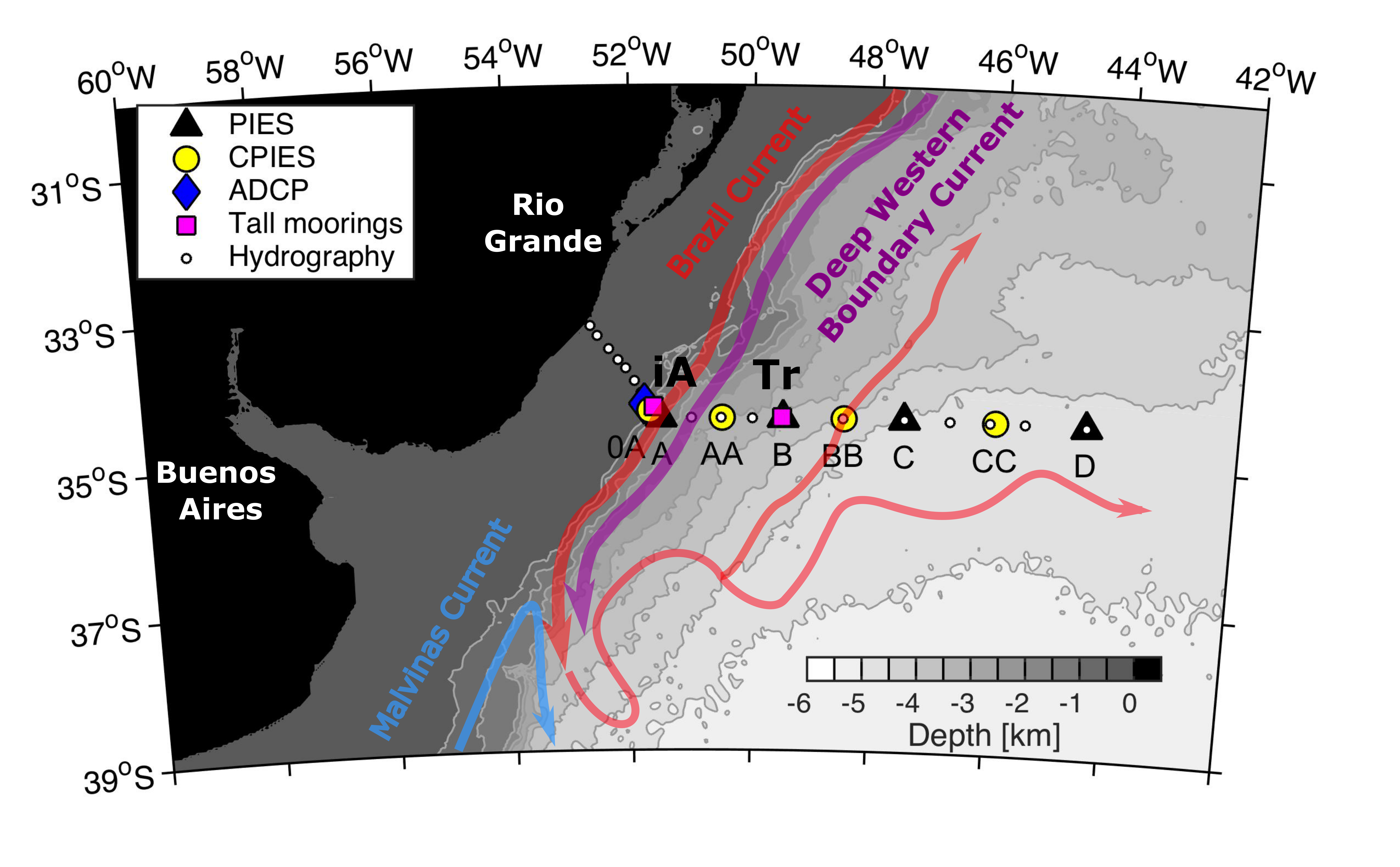
Physical processes in the Confluence region in Southern Brazil (key area 5) Rafael Avila, José Henrique Muelbert

Laboratório de Ecologia do Ictoplâncton, Instituto de Oceanografia, Universidade Federal do Rio Grande

Key area 5 covers the coastal and open ocean provinces of the Southwestern Atlantic Ocean from Brazil’s southeast coast to Argentina’s northeast coast. The area presents a complex network of hydrographic Interactions, with several water masses, mesoscale processes, and a substantial low-salinity water input, all subjected to a variable wind pattern. Herein is presented a summary of the main physical features in the area and the respective implications in the local circulation based on the available literature and data obtained from the Copernicus Marine Service database.

The local circulation is primarily driven by two features: the Brazil-Malvinas Confluence, a region of convergence of two large-scale currents (Brazil and Malvinas currents), and the discharge from the La Plata River, which yields a large-scale buoyant plume. The Brazil-Malvinas Confluence is one of the greatest mesoscale systems in the world’s ocean, and the meanders and eddies from the convergence between the currents have a strong influence not only on the local circulation but also on the air-sea exchange processes in this portion of the Southwestern Atlantic Ocean. The La Plata discharge onto the continental shelf generates one of the largest estuarine plumes in the world. Also, it creates strong horizontal gradients, a sharp salinity front, and mixes with local water masses.

The area is under the influence of the South Atlantic anticyclone, which leads to a prevailing northeasterly wind regime throughout the year, changing to southwesterly during the passage of cold fronts. These changes in the wind pattern lead to the latitudinal displacements of the confluence and the plume, as well as seasonal upwelling in northern areas of the domain. Both features also have a great impact on the local biological productivity by creating frontal zones of phytoplankton accumulation, and the plume also injects large nutrient concentrations that spread all over the coastal areas of the key area 5.

56 Tropical Atlantic recent observations for thermocline depth, heat storage, and wind Ana Clara B. Mariani, Maurício R. Rocha, Paulo S. Polito and Olga T. Sato

Oceanographic Institute of the University of São Paulo

The tropical Atlantic ocean is in a unique position that connects the North Atlantic region of deep water formation with the South Atlantic which has a direct connection to the Southern, Pacific, and Indian Oceans. The ocean upper layer in the tropical Atlantic has become warmer in recent decades.

However, that occurred unevenly along the basin, with large warming trends observed in the eastern tropical Atlantic. In that, the long-term variation in thermocline depth is a crucial aspect of ocean heat balance and transport. We investigate thermocline depth trends over the past decades using two proxy variables: a fixed 20°C isotherm and the hinge point of an adjusted hyperbolic tangent function. We used temperatures from three reanalyses (GECCO3, ORAS4, and IAP) and from PIRATA moorings located at 4°N 23°W, 0°N 23°W, 0°N 10°W, and 0°N 0°W. The thermocline depth showed no significant linear trend in the period between 1999 and 2018. The quest for a trend in thermocline depth proved quite challenging due to data gaps and time series extension, such that the results do not yet support a firm conclusion.

The east side of the basin is a region of positive heat storage (HS) trend, while the wind magnitude has a negative trend. The HS was computed from altimetric data and the wind magnitude was computed from the OAFlux dataset. This warming pattern could be caused either by changes in the heat flux at the air-sea interface due to changes in wind patterns or by oceanic processes, such as the weakening of the atlantic meridional overturning circulation (AMOC), or a combination of both.

However, there is still no agreement on the long-term weakening of the AMOC, and some studies argue that the strength of the AMOC does not show significant long-term trends in recent decades.

78 Reconstruction of the marine carbonate system at the Western Tropical Atlantic: trends and variabilities on 20 years of PIRATA project Carlos Augusto Musetti de Assis; Leticia Cotrim da Cunha; Luana Queiroz Pinho

GEOMAR; UERJ

This study aims to reconstruct the surface marine carbonate system from 1998 to 2018 using sea surface temperature (SST) and sea surface salinity (SSS) data from the PIRATA buoy at 8°N 38°W and describe its variability in time.

Two empirical models were used to calculate total alkalinity (TA) and dissolved inorganic carbon (DIC) from SSS, from which pH, in total scale, and CO2 fugacity (fCO2) values were then estimated. Only DIC, pH and fCO2 showed a statistically significant trend in time, where DIC showed an increase of 0.717 ± 0,108 µmol kg-1 year-1, pH decreased 0.0014 ± 0,0001 pH units year-1, and fCO2 had an increase of 1.539 ± 0,028 µatm year-1.

Two different seasons were observed when data were analyzed: a dry season from January to June, when SSTs were lower (27.00 ± 0.61°C) and SSS was higher (35.94 ± 0.34), matching the period when the ITCZ is over the South American continent, Amazon river plume is restricted to western shelf areas and Equatorial upwelling is less intense, and a rainy season from July to December, when SSTs were higher (28.35 ± 0.7°C) and SSS was lower (35.01 ± 0.8), matching the period when the ITCZ is at its northern range, the Amazon plume is spread eastwards through the North Brazil Current’s retroflection and the Equatorial upwelling is more active. Along with that, TA, DIC and pH varied positively with SSS, with higher values (TA: 2352.88 ± 19.74µmol kg-1; DIC: 2013.82 ± 18.6µmol kg-1; pH: 8.0604 ± 0.0121) during dry season and lower values (TA: 2299.3 ± 46.32µmol kg-1; DIC: 1967.61 ± 40.0µmol kg-1; pH: 8.0485 ± 0.0119) during rainy season. On the other hand, fCO2 varied positively with SST, with higher values (391.13 ± 13.76µatm) during rainy, upwelling season and lower values (385.85 ± 12.86µatm) during dry season.

66 Stable isotope variability in a tropical zooplankton time series explained by its key species Morgana Brito-Lolaia, Gabriela Guerra Araújo Abrantes de Figueiredo, Sigrid Neumann-Leitão, Gilvan Takeshi Yogui, Ralf Schwamborn

Dept. of Oceanography, Federal University of Pernambuco (UFPE), Av. Arquitetura s/n, Cidade Universitária, Recife, PE 50740-550, Brazil

Time series play an essential role in the study of marine ecosystems, including zooplankton communities and their stable isotope (SI) signatures. SI analysis of ecosystems is generally based on the measurement of a few individuals from a small list of subjectively pre-defined species.

The main objective of this study was to detect species that are significantly associated with the temporal variability of the SI composition of coastal zooplankton in the Tropical West Atlantic. We investigated this by means of a novel species-biomass-isotopes-mixture (SBIM) approach. SBIM was applied to detect key taxa that can be considered bioindicators for important descriptors of ecosystem state (e.g., oligotrophy, carbon sources, mean trophic level). Zooplankton samples (64 µm mesh size) were obtained in Tamandaré Bay (northeastern Brazil) from June 2013 to August 2019 for stable isotope measurements and estimation of size and relative biomass. Zooplankton δ13C ranged from -21.0 to -18.2‰ (mean: -19.7‰ in the dry season and -19.4‰ in the rainy season). Total zooplankton δ15N ranged from 3.8 to 9.0‰ (7.0‰ in the dry season, and 6.5‰ rainy season). Total zooplankton C/N ratios ranged from 3.5 to 5.0 (4.2 in the dry season and 4.2  in the rainy season). The copepod Pseudodiaptomus acutus was the most important species for explaining the variability in δ15N (22% of the total variability). Relative biomass (%) of P. acutus showed a strong positive correlation with δ15N, indicating a high trophic level (TL).  Small-sized invertebrate larvae were negatively correlated with δ15N, indicating a TL below average.  The tintinnid F. ehrenbergii showed a positive correlation with C/N, being an indicator for turbid “green waters”, during the rainy season, when the ecosystem was in a eutrophic state, with high lipid contents in the zooplankton community. The proposed SBIM approach opens up a novel pathway to understanding the factors and species that shape the temporal variability of food webs and a new way to look at SI data of zooplankton communities.

61 Using otolith biochronologies from sardine (Sardinops sagax) in the southern Benguela to identify ecosystem shifts Faye Brinkman1, Margit Wilhelm1,2, Yonela Geja3 & Carl D. van der Lingen3,4

1 Department of Fisheries and Aquatic Sciences, University of Namibia, Henties Bay, Namibia.

2 Sam Nujoma Marine and Coastal Resources Research Centre (SANUMARC), University of Namibia, Henties Bay, Namibia.

3 Branch: Fisheries Management, Department of Forestry, Fisheries and the Environment (DFFE), Cape Town, South Africa.

4 Department of Biological Sciences and Marine Research Institute, University of Cape Town, Cape Town, South Africa.

Southern Benguela sardine Sardinops sagax has shown substantial changes in population size over the past 70 years. We developed a robust 49-year (1962-2010) otolith biochronology of annual increment width to infer long-term growth patterns of sardine sampled off the South African west coast. Linear mixed effect models were applied to separate intrinsic (within individual) and extrinsic (by year – e.g. population density, environment) factors to estimate mean annual growth. Sequential t-test of regime shifts (STARS) analysis performed on the best linear unbiased predictor (BLUP) of the year effect on fish growth indicated three regimes with two alteration points. The first alteration occurred in 1986 from well-below average growth to well-above average growth, and the second in 2006 from well-above average growth to average growth. These three regimes correspond with periods of low, high, and low biomass, respectively; i.e. well-above average growth rates occurred during the high biomass period and vice versa. Sardine is expected to grow faster to reach maturity earlier at low biomass. The pattern of slow growth at low biomass is counter-intuitive and suggests that environmental conditions may have been primarily responsible. These findings indicate that sardine growth is influenced by both biomass levels and environmental conditions, and that the relative effect of each can change over time. Further work is needed to elucidate this, but our study demonstrates the utility for developing otolith increment methods to identify ecosystem shifts in the Benguela ecosystem, and will contribute to an ecosystem approach to management of the fishery.
60 Marine heatwaves in the Cape Peninsula Upwelling Cell Kirstin Petzer, Prof. Mathieu Rouault and Dr. Tarron Lamont

University of Cape Town, Nansen Tutu Center for Marine Environmental Research

Due to global warming, marine heatwaves are considered to be one of the emerging threats to marine ecosystems globally. South Africa’s fisheries and coastal communities depend on the Southern Benguela’s upwelling for the high marine productivity. Marine heatwaves are prolonged periods of extreme warm Sea Surface Temperatures (SST) anomalies which could have severe ecological impacts on marine ecosystems by decreasing biodiversity, negatively affecting cold water species and increasing ocean stratification. Council for Scientific and Industrial Research (CSIR) half-hourly in situ SST from the Cape Point station about 5.4 km of the coast, and ECMWF Reanalysis 5th Generation wind speed and direction time series from January 2003 to March 2020 were examined to quantify the occurrence, formation and decay of marine heatwaves in the Southern Benguela. The marine heatwaves were identified using the SST values which exceed the 90th percentile of the timeseries for at least five days. In the CSIR SST time series 18 marine heatwaves were identified at the Cape Point station. The occurrence of strong north-westerly winds was found to be the main driver of marine heatwaves, while southeasterly winds was observed to have a large role in the decay of marine heatwaves. Marine heatwaves are expected to worsen with climate change by lasting longer with high temperature increases but increase in southeasterly winds could decrease the occurrence of marine heatwaves in the Southern Benguela.

Key words: Southern Benguela, marine heatwave, upwelling

54 Disentangling the impact of Atlantic Niño on sea-air CO2 fluxes Shunya Koseki(1), Jerry Tjiputra(2), Filippa Fransner(1), Lander R. Crespo(1), Noel Keenlyside(1.3)

1: Geophysical Institute, University of Bergen 2: NORCE 3: NERSC

The Atlantic Niño is a major tropical interannual climate variability mode of the sea surface temperature (SST) occurring during boreal summer that shares many similarities with the tropical Pacific El Niño.

Although the tropical Atlantic is an important source of CO2 to the atmosphere, the impact of Atlantic Niño on the sea-air CO2 exchange is not well understood. We reveal that the Atlantic Niño enhances (weakens) CO2 outgassing in the central (western) tropical Atlantic.

In the western basin, freshwater-induced changes in surface salinity, which considerably modulate the surface ocean CO2 partial pressure (pCO2), is the primary driver for the observed CO2 flux variations. Contrastingly, pCO2 anomaly in the central basin is dominated by the SST-driven solubility change. Here, we reveal that this multi-variable mechanism for pCO2 anomaly differs remarkably from the Pacific where the response is predominantly controlled by upwelling-induced dissolved inorganic carbon anomalies.

The contrasting behavior is characterized by the high CO2 buffering capacity in the Atlantic, where the subsurface water mass contains higher alkalinity than in the Pacific. The different mechanisms driving the interannual variability in sea-air CO2 exchange in the tropical Atlantic and Pacific suggests that they may respond differently to climate change.

39 The deep chlorophyll maximum in the tropical Atlantic: is it a phytoplankton biomass maximum? Cristina González-García1, Mike V. Zubkov2, Emilio Marañón1

1Departament of Ecology and Animal Biology, University of Vigo, Vigo, Spain

2Scottish Association for Marine Sciences, Scottish Marine Institute, Oban, United Kingdom

The deep chlorophyll maximum (DCM), a peak in chlorophyll concentration located near the bottom of the euphotic layer, is a widespread biological feature in all stratified oceanic regions. The ecological and biogeochemical significance of the DCM depends on whether it reflects an actual maximum in phytoplankton abundance and biomass, or arises from an increase in chlorophyll cellular content (photoacclimation).

Recent analyses of fluorescence and backscattering profiles from Argo floats have identified the DCM in subtropical gyres as being caused mainly by photoacclimation, whereas the DCM in equatorial regions was classified as a maximum of phytoplankton biomass. However, geographical coverage of available Argo profiles in tropical regions is sparse, particularly in the south Atlantic. In addition, the backscattering signal can be affected by non-phytoplankton material, including heterotrophic bacteria and detritus. It is thus of interest to examine the available evidence on the vertical distribution of phytoplankton abundance in tropical regions, in order to verify if inferences based on fluorescence and backscattering profiles are valid.

Here we use phytoplankton abundance measurements obtained during two Atlantic Meridional Transects to ascertain if the DCM is a maximum of phytoplankton biomass in the Atlantic subtropical gyres and equatorial region.

36 Fisheries and environmental variables reveal migration patterns of albacore Thunnus alalunga (Bonnaterre, 1788) in the South Atlantic Ocean Previero, M., Travassos, P. and Andrade, H.

Departamento de Pesca e Aquicultura, Universidade Federal Rural de Pernambuco (UFRPE)

The albacore (Thunnus alalunga) fishery is amongst the main important in the South Atlantic Ocean. Albacore is a migratory species alternating periods in tropical and temperate waters. While adults migrate to tropical warmer waters, with reproductive purposes, juveniles inhabit high southern latitudes.

Here the albacore adults and juveniles migration in the South Atlantic were modeled and mapped. Fishery data (catch, effort and fish sizes) were obtained from ICCAT databases to China Taipei longline fleet. Sea Surface Temperature (SST, ºC) and Chlorophyll-a (mgg) were obtained from NASA. The dataset were compiled by month and 5°x5° spatial resolution to 1997-2020. A Random Forest model by month to juveniles and adults separately relating catch data and environmental variables was performed.

The model results were spatialized using a predict function in rasterized shapefiles of SST and  Chlorophyll-a for each 1°x1°. The highest abundance spatial patches were evidenced. The temporal trends of abundance, SST and Chlorophyll-a were also investigated. Different migration patterns were found to adults and juveniles. Between August and September, adults start a migratory movement from the southern African coast to the area off the north-east Brazilian coast, above 20oS. In this tropical warm water zone, from October to February the adults spawn and returns to temperate areas. On the other hand, juveniles remain in subtropical areas (30°S-40°S) throughout the year. The results indicate the tropical migration possibly has reproductive character, being performed mainly by adults and some pre-adults. The SST and Chlorophyll-a seems do not influence this adults migratory pattern. These large-scale displacements may be associated with the fulfillment of species’ reproductive task to seek the same spawning area previously defined throughout its evolutionary cycle. Regarding juveniles being a temperate tuna species, their distribution is restricted to higher latitudes. They begin to participate in this migration to tropical areas when reach sexual maturity, contributing to the stock reproductive process.

The results obtained may contribute both to the species’ spatial management and to future studies on migration in climate change scenarios.

88 Evaluation of Benguela Niño-Niña events in the CMIP6 historical simulations Marie-Lou Bachelery1, Shunya Koseki1, Noel Keenlyside1

1- Geophysical Institute, University of Bergen, Bjerknes Centre for Climate Research, Bergen, Norway

Historical Coupled Model Intercomparison Project Phase 6 (CMIP6) model outputs are analyzed to evaluate models’ ability in simulating the seasonal and interannual variability in the South-Eastern Atlantic Ocean. The study focuses on SST in February-March-April, the main season of occurrence of the extreme interannual warm and cold Benguela Niño-Niña events.

In the Angola-Benguela-Area (ABA), the CMIP6 SST ensemble-mean resembles the seasonality of the observations but with a strong bias. Unlike the seasonal cycle, the SST interannual variability in CMIP6 ensemble-mean is underestimated and occurs 3-4 months after the peak of maximum variability in the observations (June/July). Among the model ensemble, 2 groups of models emerge: a group featuring a maximum interannual variability in the right location (ABA) but delayed by about 2/3 months compared to the observation (~60% of the models); a group featuring the maximum variability in the right season (FMA) but in a location shifted southward in the South-Benguela (~30% of models). For the first group, results suggest that the time-shift of the peak in the SST variability is induced by the time-shift of the equatorial zonal wind stress. For the second group results show that the latitudinal-shift of the peak in SST variability is controlled by intense coastal wind activity in the south Benguela rather than by model bias and a southward shift in the position of Angola-Benguela-Frontal Zone.

Finally, we examined the models’ ability in simulating extreme interannual Benguela Niño-Niña events. Very few individual models correctly simulate the phenology of the Benguela events, including the modulation of the equatorial zonal and coastal winds that drive development in the preceding months. Interestingly most of the best models have in common a fairly good representation of the South-Atlantic High pressure system.

85 Marine protected areas in face of global warming in the Tropical Western Atlantic (Brazilian Coast) A.S. LIRA1; F. LUCENA-FRÉDOU1; M.A.L. LIMA2; L.N. EDUARDO3; L. CAPITANI2; T. FRÉDOU1; A. BERTRAND3; J. STEENBEEK4,5; M. COLL5; R. ANGELINI2

1-Fisheries and Aquaculture Department, Federal Rural University of Pernambuco, Rua D. Manuel de Medeiros s/n, Dois Irmãos, CEP 52171-900, Recife, Pernambuco, Brazil.

2-Civil Engineering Department, Federal University of Rio Grande do Norte, Campus Universitário Lagoa Nova, CEP 59078-970, Natal, Rio Grande do Norte, Brazil.

3-Institut de Recherche pour le Développement (IRD), MARBEC, Univ Montpellier, CNRS, Ifremer, IRD, Sète, France

4-Ecopath International Initiative Research Association, Spain.

5-Institute of Marine Sciences, Spanish National Research Council, Spain.

Marine ecosystems are threatened by climate change, overfishing and loss of biodiversity, which has led to the use of approaches that consider methods to quantify and mitigate these threats.

The Ecospace model for Northeast Brazil (NE) aims to assess the species distribution, in terms of biomass, catch, and ecological indicators under different climate scenarios (e.g. global warming) and the establishment of Marine Protected Areas (MPAs) to explore their effectiveness for maintenance of biodiversity in the region. The analysis encompasses 31km2 off the NE coast, considering over fifty-five compartments and different layers such as depth, Sea Surface Temperature and Seabed morphology. The multi-decadal to centennial forecasts according to the Fish-MIP protocol were simulated from 2015 to 2100 after the historic trend calibrated, using annual fishing time series (1987-2007). The Earth-System Model from Geophysical Fluid Dynamics Laboratory (GFDL-ESM2M) projections of historic and ssp126 (RCP 2.6) and 585 (RCP 8.5) climate scenarios were used to evaluate the responses of functional groups to changing average water temperatures for the top 150 meters. In addition, the GFDL projections were applied to force phytoplankton biomasses over time. Overall, the increase of temperature not reflected in a significant decrease of biomass and capture of all groups evaluated on the multi-decadal to centennial forecasts. However, some species (e.g., Lutjanus spp and Epinephelus spp) were strongly impacted, mainly in the intense global warming scenarios (RCP8.5). In contrast, the MPAs implementation in face of global warming scenarios was promising, increasing the biomass for some species, mainly in the no-fishing areas, where biomass hot spots were observed. In terms of Ecological indicators (e.g., biodiversity indicators and biomass of fish), differences were observed between the (RCP8.5) and (RCP2.6) scenarios, especially in the year after 2070s. We conclude that the increase of temperature cause negative impacts on the biomass mainly in the commercial species of high trophic level. However, MPAs play an important role in maintaining the biomass of these groups and the biodiversity of the ecosystem.

79 ECOSYSTEM INTERACTIONS AND FUTURE SCENARIOS AT THE AMAZON RIVER MOUTH Maria Alice L. Lima (Federal University of Rio Grande do Norte);

Flávia Lucena-Frédou (Federal Rural University of Pernambuco);

Bianca Bentes (Federal University of Pará);

Victoria Isaac (Federal University of Pará);

Tommaso Giarrizzo (Federal University of Ceará);

Tatiane Medeiros (Federal University of Pará);

Ronaldo Angelini (Federal University of Rio Grande do Norte)

Estuarine areas are the most productive ecosystems, concentrating many activities supported by nutrient enrichment of the rivers. The Amazon River is the largest in the world in water discharge. Its adjacent estuary covers a total area of 112,699.7 km², supporting the capture of many fish species and other organisms such as shrimp. This study aims to develop a trophic model for the mouth of the Amazon River, evaluate the crucial shrimp fishery activity in the region, and assess climate change’s effect on fishing activity and natural resources. Using the Ecopath with Ecosim software, we built the trophic model of this area with approximately 50,000 km2. Functional groups to the Amazon River mouth region model were chosen according to a) importance in the fisheries experimental samples in 2019; b) importance in fishing landings; c) vulnerable and charismatic species, such as turtles and dolphins. Other fish species with low biomass were grouped in functional groups according to their trophic categories. The model comprises 56 functional groups, of which 34 are fish and one compartment for detritus. Our complete model is composed of marine (as Lutjanus spp), estuarine (as Cynoscion spp), and freshwater (as Brachyplatysoma spp) species, all of which are important for commercial fisheries. Shrimp species are also key in fisheries, and four of them were included in the model: Farfantepenaeus subtilis, Xiphopenaeus kroyeri, Nematopalaemon schmitti, and Litopenaeus schmitii. The history of fisheries production in the North region was evaluated in the period between 1976 to 2015 from official national databases. The Ecosim module helps assess observed and estimated trends in the time series of catches available for some functional groups. We propose simulating commercial species’ scenarios and responses using temperature changes and effort. The Amazon River ecosystem is expected to be a resilient system, with high cycling and respiration values, in addition to the importance of the detritus chain for the system. These results with ecosystem approaches are designed to help the management and management of natural resources and support the sustainability of commercial capture.
76 Tropical Atlantic forcing of different ENSO regime Noel Keenlyside, Hui Ding, Marta Martín del Rey, Irene Polo, Belen Rodrigues-Fonseca, Fred Kucharski

University of Bergen, University of Colorado, Universidad Complutense de Madrid, International Centre for Theoretical Physics

The El Niño Southern Oscillation (ENSO) underwent a major shift in in the 1970’s, become stronger and more predictable. This shift has been attributed to changes in the tropical Pacific mean state. However, around the 1970’s, tropical Atlantic – Pacific variability became coupled, with Atlantic SST leading opposite signed changes in the Pacific by around 6-months.

Here we assess the role of the Atlantic in driving the ENSO regime shift using pacemaker experiments with two climate models: ECHAM5/MPIOM and SPEEDY/RGO. In these experiments, model SST is restored to observations in the tropical Atlantic, while elsewhere the models are fully coupled. Both models capture the observed changes in inter-basin interactions and strengthening on ENSO variability after the 1970’s.

The warming of the equatorial and south Atlantic and southward shift of the inter-tropical convergence zone causes inter-basin interactions to become active after the 1970’s in the models. In ECHAM5/MPIOM, this leads to Atlantic Niño variability driving increased ENSO activity. In SPEEDY/RGO, the increase in ENSO activity appears more related to induced mean state changes in the Pacific.

75 Global spatial-temporal trends of tuna ex-vessel price Eurico Mesquita Noleto Filho 1; Ronaldo Angelini 1; Paulo Eurico Pires Ferreira 2; Flávia Lucena Frédou 2; Thierry Frédou 2; Sebastian Villasante 3; Vicky Lam 4; Ussif Rashid Sumalia 4; Adriana Rosa Carvalho1

1-Federal University of Rio Grande do Norte, Brazil; 2- Universidade Federal Rural de Pernambuco, Brazil; 3- University of Santiago de Compostela, Spain; 4- University of British Columbia, Canada

Tuna species are an important economic commodity that plays a critical role in keeping the health of marine ecosystems and are under threat by overfishing. Proper estimation of the tuna ex-vessel prices is difficult, given that most species are highly migratory and exploited all over the globe. So, it is hard for Regional Fisheries Management Organizations (RFMOs) to decide whether or not to establish integrated management policies, since the link between regional markets is not completely understood. The spatial structure might be a key element for successfully estimating a price assessment model for this species. Yet, modeling complex spatial data can be difficult and time-consuming for both frequentist methods and Bayesian models with Monte Carlo Markov Chains (MCMC). The Integrated Nested Laplace Approximation (INLA) is a faster alternative to MCMC and is suitable to model the uncertainties in data. Here we estimate and predict the spatial-temporal patterns of the ex-vessel price of four species of tuna: skipjack (Katsuwonus pelamis), yellowfin (Thunnus albacares), bigeye (Thunnus obesus), and albacore (Thunnus alalunga). For that means, we modeled a dataset from 2001 to 2018 from Sea Around Us, using Bayesian Hierarchical Spatio-Temporal Models. For the majority of species, we discovered significant price elasticity across areas, indicating that country economies may be more closely tied to a species’ global price cointegration than oceanic regions are.
70 Adaptation of a bi-frequency discrimination method to the copepods in the Senegalese coast Ndague DIOGOUL

IRD Lemar/ ISRA, CRODT, BP 2221 Dakar, Senegal

Underwater acoustics sampling techniques provide an benefit over traditional net sampling for macrozooplankton research due to its high spatial coverage. Estimation of abundance or biomass, using acoustic techniques requires knowledge of the frequency dependent acoustic backscatter characteristics, or target strength (TS) of insonified organisms. The TS of zooplankton is usually estimated from physics-based models but can also be made in field. To do so we applied an inversion method, which combine both acoustic and biological data for discriminating zooplankton copepod. We examined echo sounder data at 38 and 120 kHz, collected during a fisheries acoustics survey carried out off Senegalese over the continental shelf. Biological samples collected with a Multinet were used as ground truth. We identified copepod backscatter using differences in volume backscattering strength (Sv) measured at both frequencies. A close relationship were found between the measured values of copepod from Multinet with those calculated by the standard and simple model used. The correlation between copepod abundance and corresponding Sv were positive. This work showed that acoustic method can provide information on a key component of the lower trophic levels in Senegalese water i.e. the   copepods (>1mm). These results are essential to better understand marine ecosystem, and constitute a first step for copepod biomass estimation in the   study area.

Keywords: Acoustic, bi-frequency, copepod, volume backscattering strength.

63 Variabilidade espaço-temporal da salinidade e transporte no Oceano Atlântico Tropical (N e NE do Brasil) baseados em dados observados e modelagem numérica Ricardo Christyan Matos Carvalho, Geórgenes Hilário Cavalcante Segundo

UFAL

As variações de longo prazo da Circulação de Revolvimento Meridional do Atlântico podem levar a mudanças regionais na distribuição da temperatura (TSM) e salinidade (SSM) da superfície do mar. Tais processos afetam os transportes latitudinais de calor e sal, e como consequencia final, o estabelecimento das correstes de contorno oeste do Atlântico Sul, como a Corrente Norte do Brasil (CNB) e Corrente do Brasil (CB). Neste trabalho, usaremos produtos de sensores instalados em satélites para medir a salinidade da superfície do mar (SSM), em combinação com dados de modelo numérico (HYCOM), e medições em in situ da salinidade na superfície do mar, a fim de explorar a variação sazonal das correntes de superfície e salinidade médias nas regiões norte e nordeste do Brasil. A análise de ondelatas permitirá decompor as séries temporais em diferentes níveis de resolução tempo-frequência para determinar as componentes da variabilidade dominantes. As análises produziram estimativas da variação sazonal das correntes e salinidade. Esta informação será então aplicada aos produto de satélite SSM para obter mapas de velocidade da água e transporte de sal, levando a um ferramenta para estimar o transporte de água e sal em regiões específicas do Atlântico Tropical.
62 Quasi-decadal to interdecadal SST variability in the Benguela Upwelling System Folly Serge Tomety and Mathieu Rouault

Nansen-Tutu Centre for Marine Environmental Research, Department of Oceanography, University of Cape Town, South Africa

The observations and reanalysis datasets are used to investigate the sea surface temperature (SST) decadal fluctuation in the southern Benguela upwelling system and their teleconnections with the global ocean. Two dominant decadal time scales of variability are identified over the twentieth century: the quasi-decadal (9-14 years) and the Interdecadal (19-26 years). The teleconnections between SST in the southern Benguela system and SST over the global ocean are different at both quasi-decadal and interdecadal time scales. At the interdecadal scale, the tropical and subtropical oceans, especially the Pacific Ocean appear to be strongly linked to the southern Benguela SST fluctuations. The teleconnections of the tropical Pacific (the El Niño Southern Oscillation ENSO-like and Pacific Decadal Oscillation (PDO)) with SB SST are statistically significant. At the quasi-decadal time scale, there is no relationship between SB SST and the climate modes used in this study. However, the composite anomalies show a link between the SB SST and the whole South Atlantic Ocean. The pattern of SB SST composite anomalies in the South Atlantic is reminiscent of the South Atlantic Subtropical Dipole mode (SASD), the dominant mode of variability in the South Atlantic Basin.
58 A cooperative response to the paraíba oil spill incident: results from a tactical-operational exercise Diego Xavier Bezerra

National Institute for Space Research

The appearance of oil slicks on the beaches of Paraíba, during the days of December 31st, 2021 and January 3rd, 2022, provided an opportunity for the coalition of the Brazilian scientific community on the topic of detection, prediction and monitoring of oil spills at sea, in the interest of deterring future incidents. The search for the best available scientific knowledge is fundamental and a guiding element to improve the correct preparation for potential future oil spill incidents in the Blue Amazon, starting with the establishment of inclusive mechanisms of technical-scientific articulation, aiming to increase detection capacity, impact prevention, and timely response actions. The recent allocation of resources by the MCTI/FINEP to the development of a “multi-user system for the detection, prediction and monitoring of oil slicks at sea” (SisMOM), with the participation of INPE, Science and Technology Institutes, Brazilian Navy and IBAMA, is for the Brazilian nation a fact that brings a better future when faced with incidents of oil spills at sea. The present work constitutes a tactical-operational demonstration of the analysis, synthesis and response capacity of researchers and institutions involved in a multi-user system (SisMOM) to articulate themselves permanently in response to incidents of oil spills at sea. The proposed method, based on oil spill trajectory modelling and analysis of Automatic Identification System (AIS) constitutes a practical solution for improving maritime domain awareness and fast oil spill response.
34 A Lagrangian study of cross-basin, seasonal connection in the Tropical Atlantic Emanuel Giarolla and Paulo Nobre

Brazilian National Institute for Space Research

Av. dos Astronautas, 1758

In August of 2021, the presence of marine debris, including plastic materials and tar balls, were reported along the beaches of Fernando de Noronha archipelago, located 354 km offshore from the Brazilian coast (3°51′S, 32°25′W). Here, we investigate the debris’ many possible origins, it was questioned whether such debris could come from regions as far as the African coast.

A set of experiments were performed with a Lagrangian model (Ocean Parcels), using Mercator ocean surface currents (1/12o  global analysis forecast “phy_001_024”). The “backward” simulations (going back in time) showed that parcels (or  particles), released near the Fernando de Noronha beaches, eventually reach the African coast, spending a whole year in this journey. On the other hand, in “forward” simulations releasing the parcels near the African coast, e.g., close to the Congo river basin, the particles usually keep trapped  in that regional ocean circulation for weeks and, under some circumstances depending on the season of the year, ultimately are captured by the main Atlantic ocean circulation, then increasing the chances of those set of particles to reach the archipelago beaches region in the course of time.

23 Spatial distribution of Caretta-Caretta turtle and the Florida current transports at interannual timescales L. Sánchez-Gabán (1), I. Polo (1), F. Ramírez (2)

(1) Dpto. Física de la Tierra y Astrofísica, UCM, Spain (2) ICM-CSIC, Barcelona, Spain

The Atlantic Meridional Overturning Circulation (AMOC) is the main system for the exchange of water, heat and carbon across the North Atlantic. It distinguishes a northward flow of warm, shallow water and a southward flow of colder, deeper water. Studies show that variability in the AMOC has an impact on climate and therefore on habitats and biodiversity. Based on observed physical and ecological data, this study aims to test the hypothesis that variability in oceanic transport in the Straits of Florida affects the distribution of Caretta-Caretta turtle. In summer, a higher density of records has been observed in coastal areas and in coastal areas and in the north, as this coincides with the breeding and migratory period. At winter, records were found in the Sargasso Sea due to the return to nesting areas due to the subtropical gyre. The results suggest that, mainly in summer, with an anomalous positive Florida transport, more records are observed in the north Atlantic, probably because the intensified Gulf Stream transports the current transports turtles further away. In contrast, with anomalously negative Florida transport, more records occur in the Gulf of Mexico and around Florida. At winter, with a positive anomalous transport, more observations occur in the Sargasso Sea, probably due to an intensification of the subtropical gyre. Despite the limitations, which mainly affect the ecological data, it is expected that an analysis of turtle trajectories will allow conclusions to be drawn about variations in the AMOC due to climate change.
97 Influence of ENSO events on the Atlantic coast of the Iberian Peninsula E. Mohino (1), I. Polo (1), B. Rodríguez-Fonseca (1), J. Miguel-Fernández (1), E. Exarchou (2), P. Ortega (2), P. Castellanos (2,3)

 (1) Dpto. Física de la Tierra y Astrofísica, UCM, Spain (2) Barcelona Supercomputing Center (BSC), Barcelona, Spain. (3) Marine and Environmental Sciences Centre (MARE), Lisboa, Portugal

In this study, we analyse the potential influence of the ENSO events in the coastal upwelling of the Iberian Peninsula as part of the Canary Current Upwelling System, considering the chlorophyll concentration as an indicator of upwelling with satellite data since 1997. The results suggest that, on the one hand, El Niño events could be leading by 10-8 months the increased of boreal summer upwelling in the Atlantic coast of the Iberian Peninsula. On the other hand, La Niña events and the increased SLP in the Azores high region, are linked to an enhancement of the coastal upwelling in that region in the month of October. Data from a biogeochemical reanalysis is compared with the observations. The influence of ENSO on Tropical North Atlantic and NAO variability could provide a teleconnection mechanism for the observed link between ENSO and enhanced upwelling in the Iberian coast.